Road Trip to SD – Day 5 – Badlands in the Morning

I wasn’t very complete in my description of Jewel Cave from Day 4 of this trip. I usually get out the brochure and re-read the info that is there. Those formations in some of the photos are called Dogtooth Spar, 6-sided calcite crystals formed completely underwater, and Draperies, formed as water trickles down, leaving deposits of calcite crystals. The brochure says that while the cave was forming it was completely submerged in groundwater that was rich in dissolved calcium carbonate. As conditions changed the calcium carbonate precipitated and formed calcite crystals off various depths and shapes on exposed surfaces.

IMG_1507

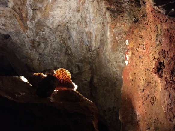
Here is one more photo from Jewel Cave. There is another cave nearby–Wind Cave National Park but we just didn’t have time for everything.

IMG_1521

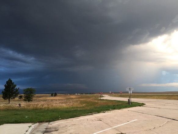
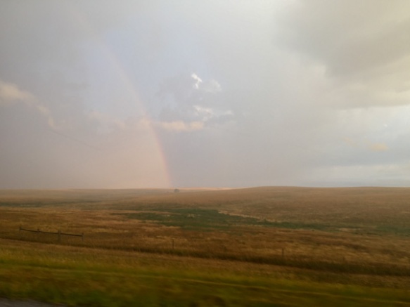
I left off the last post with heading to a Rest Stop in the dark. That was not our best night but at least we slept. However we had chosen this plan after passing up the trailhead parking that said “No Overnight Camping”. We didn’t want to be federal criminals. I will admit here that we are now criminals in the State of South Dakota. The rest stop had a sign posted about a SD rule that you can’t stay more than three hours at a rest stop and there was video surveillance for our safety. I keep expecting to get a summons in the mail.  The photo above is what we woke up to. That weather system was in the west, where we were headed to see the Badlands.

IMG_1524

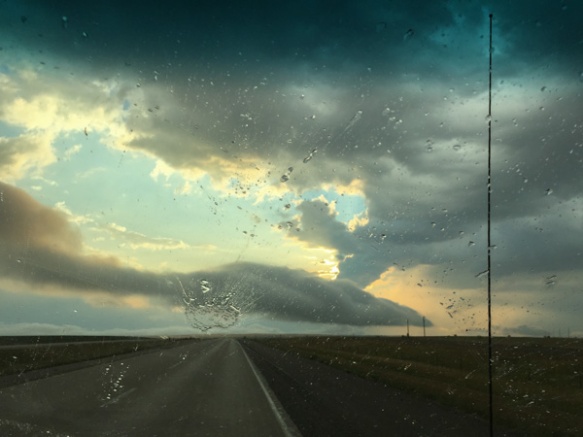
We first had to drive east to find a place to turn around. We commented that South Dakota has big raindrops.

IMG_1525

Now heading west.

IMG_1526

Eventually we drove through the storm, or it passed us over as it was heading east.  This was the first time that I’ve been “on the ground” in the Midwest and I found this side of South Dakota as beautiful as the Black Hills in western South Dakota, although very different.

DSC_3109

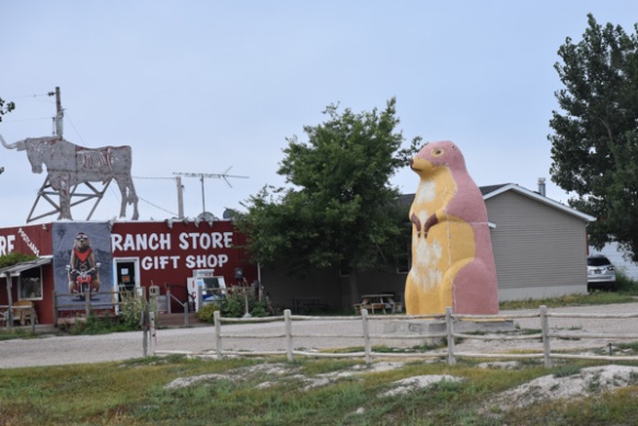
Change of pace. A bit of commercialism near the entrance to the National Park.

DSC_3110

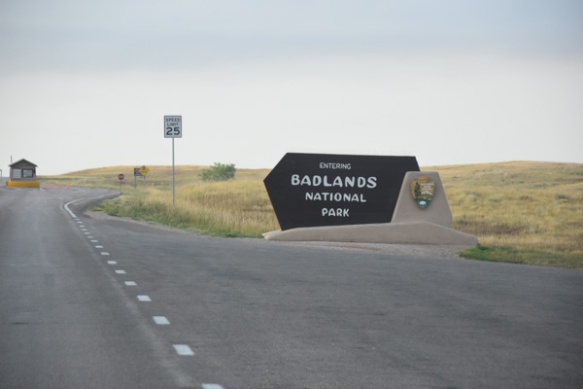
Now there was someone at the entrance station (it had been closed the night before) but there were no maps. It seems they had run out with all the motorcycle traffic. (We were able to get one at the Visitor Center.)

DSC_3111

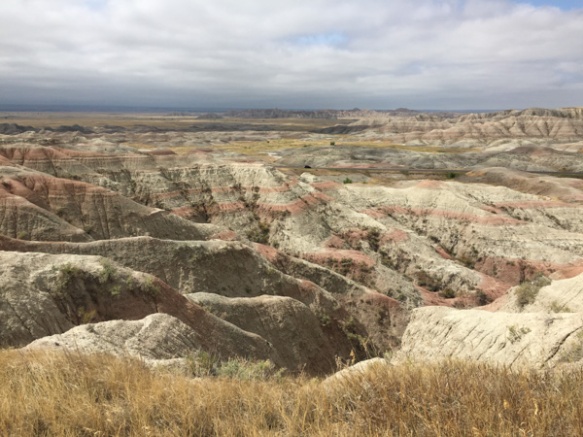
The first view of the Badlands, although we had a glimpse from the other side just before dark the night before.

IMG_1529

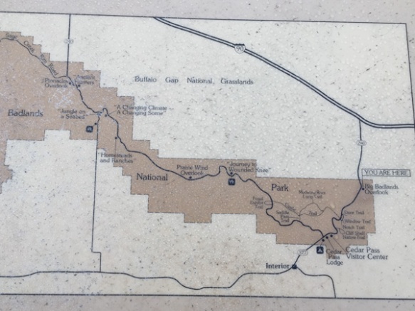
The previous night we had driven through the Buffalo Gap National Grasslands on that road south of the Badlands NP, through the eastern end of the Park and north to the highway. If we had more time we could have gone to the National Grasslands Visitor Center further west on Highway 90 in the town of Wall and the  Minuteman Missile National Historic Site just north of the Park. (Note to self: take another trip to SD and buy the Map Book first.) We planned to explore the trails here at the west end of the Park and then drive through the Park, starting our drive home.

DSC_3113

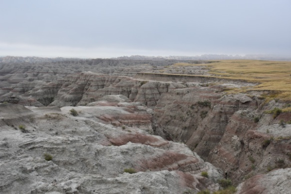
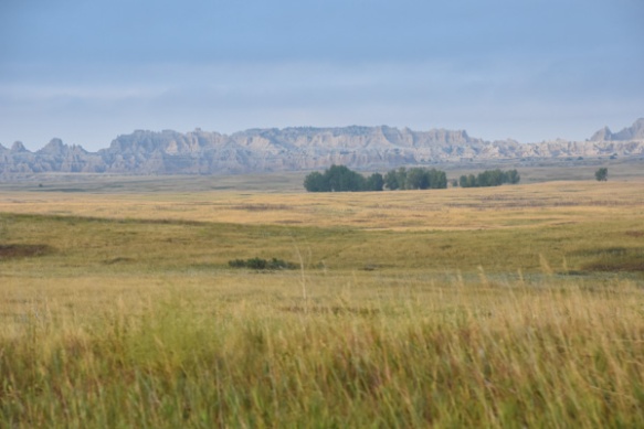
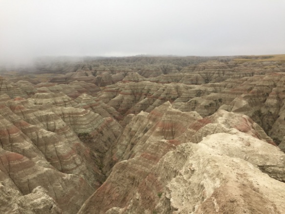
We stopped at an overlook. You can’t tell from this photo but the wind was blowing and it was cold. And what was weird is that this fog was rolling in. That sounds like something I would say standing over the San Francisco Bay. Fog rolling in here in the Badlands? In August?

IMG_1533

Maybe its not “rolling in”. But it sure settled fast.

IMG_1534

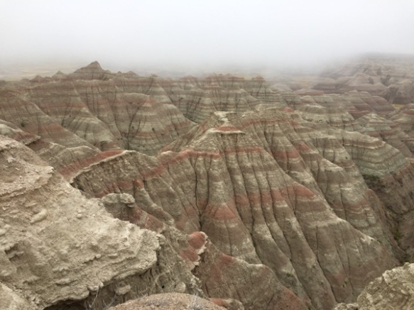
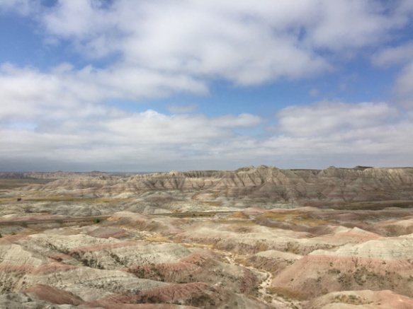
The distance view was gone within ten minutes. In fact these photos were taken ten minutes after the first one right after the National Park sign.

DSC_3116

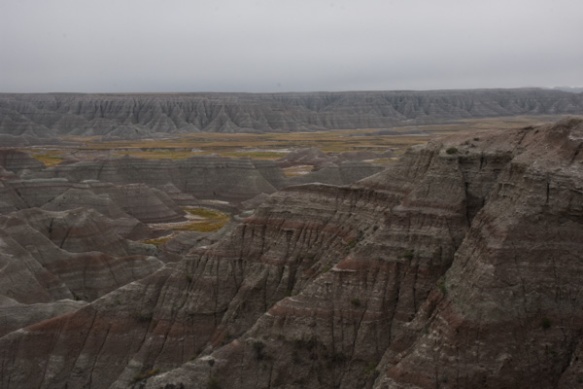
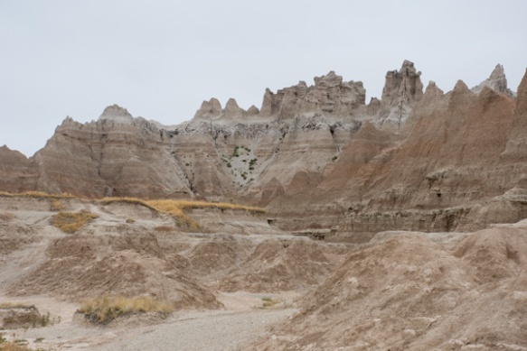
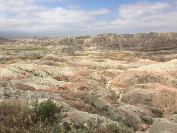
We drove on. The formations were stunning but the surroundings did seem cold and gloomy.

DSC_3122

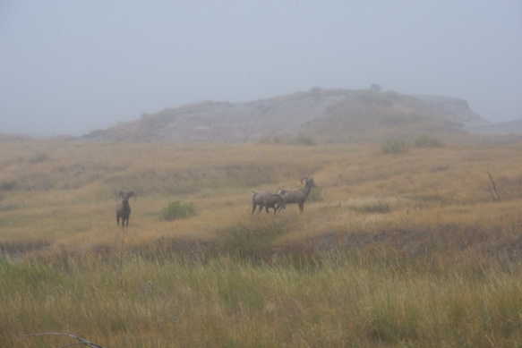
At the next stop we saw bighorn sheep! Yes! This was the clearest photo I had of them as the mist seemed to get thicker. “Sheep in Fog”. The sheep stayed around, in fact bedding down right there while we hiked on a short trail on the other side of the road.

Then we went to the Visitors Center to get warm, pick up a brochure and map, and see the exhibits.

IMG_1536

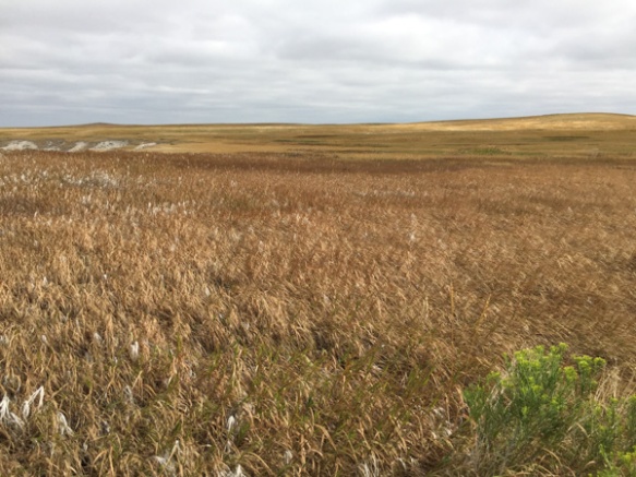
Did you know that my background is in Range and Wildlands Science? That’s what the UCD degree was called after it changed from Range Management before I graduated. I admit that I can’t identify most grasses anymore and certainly not these of the Great Plains, but I am interested. The grass is an extremely important part of an ecosystem, whether its these prairies or our irrigated pasture back home. This is a great exhibit.

IMG_1535

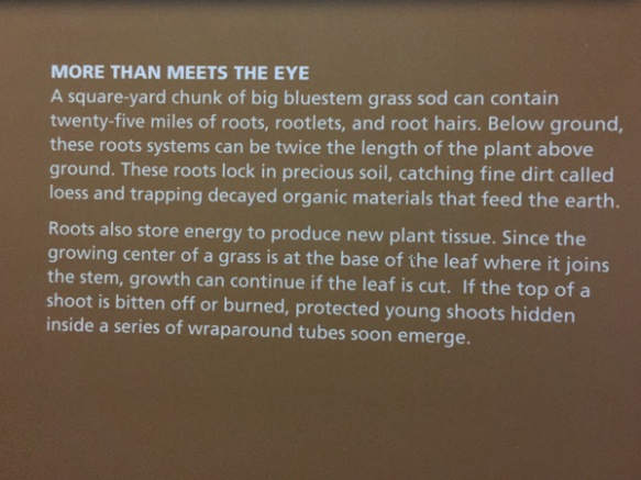
Remember the Dust Bowl? Well, most of us don’t remember it, but we know about it. This explains why, when you plow up the prairie you have set up the system for disaster. The Park brochure explains that “the Badlands prairie contains nearly 60 species of grass, the foundation for a complex community of plants and animals. The prairie once sprawled across one-third of North America.” Today there are only patchwork remnants of this prairie that “occurs in areas that are too dry to support trees but too wet to be deserts“.

DSC_3129

We drove on to the Fossil Exhibit Trail. This area went from being a under a shallow sea, to a jungle after the land lifted up, and then covered with sediment and volcanic ash that turned to soft rock. Eventually erosion exposed all the colorful layers and the fossils they hold, so the SD Badlands in known world-wide for it’s fossil record.

DSC_3139

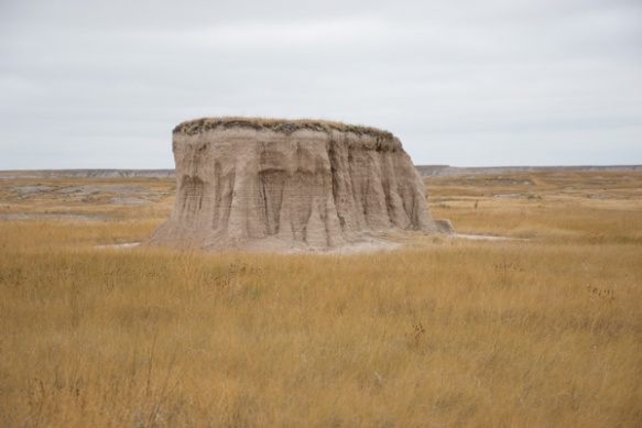
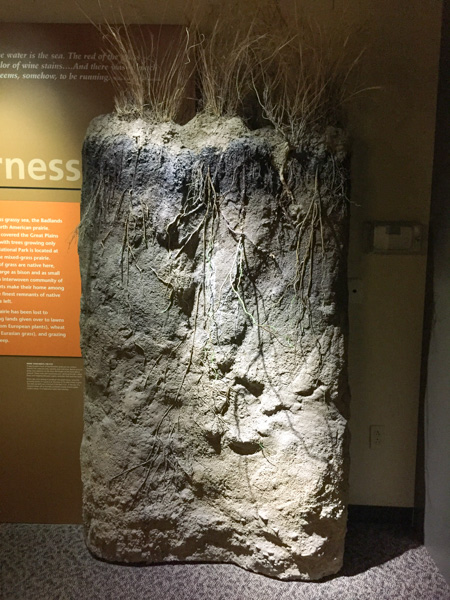
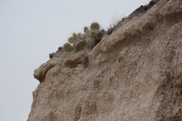
From information found on this website: “Although by definition badlands contain very little vegetation, some plants, particularly prairie grasses, are found in South Dakota’s badlands regions.  Sod tables, remnants of the prairie that have resisted erosion, provide platforms for vegetation.

IMG_1538

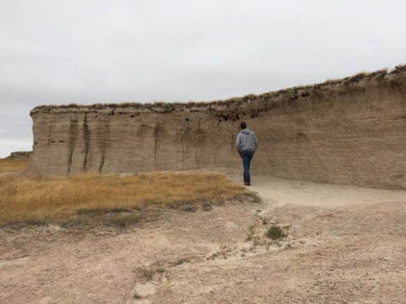
You can see the layer of soil that held by the roots of the vegetation but that isn’t enough to prevent the sides of the sod table to continue to erode. In fact, the Badlands are retreating to the north in general as natural erosion occurs. Notice the holes at the top of this sod table. We thought that maybe birds used these holes.

DSC_3138

Then we saw that these are rodent tunnels that have opened as the erosion occurs. You can see that in this photo.

IMG_1539

Beautiful landscape. What would an early explorer have thought, having just ridden over miles of grassland?

IMG_1541

IMG_1542

IMG_1543

DSC_3154

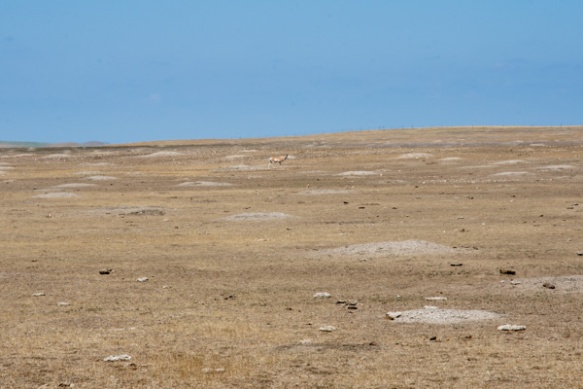
Here is a different landscape.  I might not have known for sure what this was except for having visited Devils Tower NM two days before. (By the way, there is a pronghorn in the photo but I’m talking about the mounds and the lack of grass.)

DSC_3155

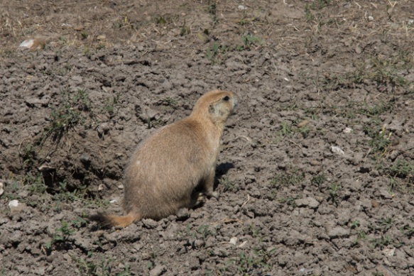
Here is the culprit. I can see how prairie dogs are considered a nuisance. The road took us past  acres and acres of this devastated landscape. As usual there are two (or more) sides to a story. I have to get on with other things right now and won’t try to research this one. Here is one article that gives various perspectives.

The day wasn’t over. We had another stop before camping for the night. That will be in the next post.


Road Trip to SD – Day 2 – Wyoming

We left Day 1 in the middle of the night in the middle of Utah.

Aragonite rest stop, UT

Several years ago Dan built a sleeping shelf in the truck (that comes out when we’re not using it). That way we can put gear underneath and leave sleeping bags, etc on the shelf. So it was easy enough to pull into the rest area near Aragonite and sleep. Just to be accurate the map book shows two spelling for this: Argonite and Aragonite, about a mile apart, and both with the symbol for abandoned settlement or railroad siding (and both on a railroad). Aragonite Incinerator is shown as a Point of Interest. It turns out that it is a hazardous waste facility. All of these points are a mile or more from the highway and the rest area.

Aragonite rest stop, UT

This is a view, looking north to the rest area and all the trucks parked there. There is a trail from the rest area to a rocky hill and a sign that says something about wild horses–so of course I needed to climb the hill. It’s not really as far as it looks–that’s just the perspective of my phone camera.

Aragonite rest stop, UT

Some of the rocks on that hill.

Great Salt Lake

After my walk we got in the truck and started driving. There is one point where the highway crosses  the southernmost part of the Great Salt Lake. Notice the salt built up around those fence posts.

Wyoming

The highway goes over most of Salt Lake City and then heads northeast to Wyoming. We got there mid-morning.

Sheep west of Lyman, WY

Remember these are all drive-by photos, some with my camera and some with my phone. This is not sharp but a photo of range sheep along I-80 west of Lyman.

Pronghorn east of Lyman, WY

Where there were alfalfa fields there were often pronghorn.

Pronghorn east of Lyman, WY

I just looked up “pronghorn”. I didn’t know that they are not really an antelope and the closest living relative is the giraffe.

Green River, WY

At about noon we stopped at a Visitor’s Center in the city of Green River. This is a view of the Green River from that point.

Joy Drill-Green River, WY

There was an outdoor exhibit about Trona. If you’re like me you’d say, “Huh?” From the brochure that calls Sweetwater County the Trona Capital of the World: “a naturally occurring mineral …is a much-needed industrial material because it yields soda ash. Soda ash is used to make glass, paper, laundry detergents and many other products. It is also used in the manufacturing of other chemicals…baking soda and sodium phosphates.” Trona occurs in other parts of the world, but not in deposits of mineable quantities.

There is a plaque with information about the equipment in the photo above. This is a Face Drill and the plaque tells about a Joseph Francis Joy, who at age 12 in the 1890s, went to work in the coal mines as had his father and brother. I assume that he went on to create this company or to inspire the more sophisticated equipment, but the sign doesn’t explain that. However any machine with this many levers seems interesting.IMG_1372

I found the Visitor’s Center to be informative and interesting–a good way to break up our drive. I was curious about a reference to the Intergalactic Spaceport and looked that up later. Wikipedia: “On July 5, 1994 Resolution R94-23 of the Green River city council designated this landing field [the airport at Green River] as the “Greater Green River Intergalactic Spaceport”, for inhabitants of Jupiter who might wish to take sanctuary in Green River in the event their planet is threatened by collisions from comets or meteors, in apparent reference to the contemporary Comet-Shoemaker-Levy9 impact”. Evidently there is a sense of humor in this town.

Green River, WY

Back outside, there were two horses from the BLM’s Wild Horse & Burro program.

IMG_1375

This is the code used for the freeze branding.

Rock Springs, WY

Speaking of wild horses, I saw on the map the BLM Wild Horse Corrals just north of Rock Springs. That is where we were turning north to head up Hwy. 191 so we stopped to look. You can request tours, but we hadn’t made any plans, so satisfied ourselves with looking from the overview. The facility can hold up to 800 horses and is the only off-range holding facility in Wyoming. It also is a rest stop for horses being transported from the West to points farther east.

DSC_2851

Heading north. It looks like all the hay that is baled around here is put into round bales. I googled “weight of round bales”. It can vary from 450 to 1700 pounds depending on size of bale, density of bale, moisture content, etc. So don’t ask me how much a round bale weighs.

Rock Spring to Eden, WY

Between Rock Springs and Eden.Rock Spring to Eden, WY

More Wide Open Spaces.

East of Eden, WY

East of Eden, WY. Isn’t that a book by John Steinbeck?

In case you are wondering about what we were doing meandering northeast through Wyoming, our first destination was to be Mountain Meadow Wool in Buffalo. We didn’t decide the order of our trip until we were actually on the road and I talked to someone at Mountain Meadow to ask about the best time to visit. This was all pretty last minute although I had the time blocked out on my calendar for months.

DSC_2862

As you know if you’ve followed our road trips in other years (search back in WordPress) we tend to stop at the historical markers we find along the way. Most of the main roads through the West were originally traveled by the Pioneers.

False Parting of the Ways, WY

A Wyoming History website says about the Parting of the Ways: “This may well be one of the most subtly dramatic sites remaining on the emigrant trails. Here, in the middle of an open, sagebrush plain, the trails diverge. Emigrants had to decide whether to stay on the main route and head southwest towards Fort Bridger or veer right and cross the Little Colorado Desert on the Greenwood or Sublette Cutoff. The cutoff, opened in 1844, saved about 46 miles but included some fifty waterless miles.” This site, however, is the False Parting of the Ways, wrongly identified in 1956 and marked with the tall marker in the background. The correct site was identified about 30 years later and the flat plaque was installed here. The sentiment remains the same though–this is part of the Oregon Trail and the country looks pretty much the same.

Oregon Trail, WY

It is so hard to imagine traveling this “road” and covering 10 to 20 miles per day.

DSC_2870

Rabbitbrush near the trail.

Hwy 28, WY, South Pass

About 7 or 8 miles away we came to the South Pass Overlook and Interpretive Site. “South Pass is the lowest point on the Continental Divide between the Central andSouthern Rocky Mountains. The passes furnish a natural crossing point of the Rockies. The historic pass became the route for emigrants on the Oregon, California, and Mormon trails to the West during the 19th century. It has been designated as a U.S. National Historic Monument.” Remember, we are following the trails backwards. The pioneers would have crossed this and then come to the Parting of the Ways and the deserts beyond.

Hwy 28, WY, South Pass

Our modern marker for South Pass.

Thermopolis, WY

After traveling north for another couple of hours it was hard to miss this sign on the mountain. We thought “sure, anyone can say they have the world’s largest anything”.

Thermopolis, WY

Then we saw it and thought they might be correct. This is in Thermopolis, population about 3000 in 2010. Back to Google and Wikipedia. “The springs are open to the public for free as part of an 1896 treaty signed with the Shoshone and Arapaho Indian tribes.”

Thermopolis, WY

This is the landscape just north of Thermopolis. Beautiful green alfalfa contrasts with the red rock.

Thermopolis, WY

The landscape reminds me of southern Utah.

Kirby, WY

Look at what I saw on the map coming up! A town named Kirby, which happens to be the name of the cutest granddaughter ever. I should get a hat or a shirt or something there.

Kirby, WY

The Kirby Bar and Grill looks promising.

IMG_1383

Kirby is not a big town.

Kirby, WY

This is pretty much it, except for a few gravel roads with houses. That’s the Bar and Grill to the left. There were people there, but no “Kirby” items to buy. We wondered about the big building at the end of the road. It seemed odd to be in this tiny town. This is Wyoming Whiskey, a distillery started and owned by a Kirby cattle ranching family. They give tours but it was closed when we were there.

DSC_2911

More landscape in the Bighorn Basin.

DSC_2916

Bighorn NF, WY

It was evening when we got to the Bighorn National Forest, part of the Bighorn Mountains. We hoped to find an open campsite. We had blocked out two weeks in which to take this trip and then chose the first week so that we would miss the hoards of people traveling to this area on Eclipse Weekend. What we didn’t realize was that this was Sturgis Weekend, a motorcycle rally that draws 500,000 motorcycles, mostly (it seems) Harleys, to the small town of Sturgis, South Dakota, just over the border from Wyoming. The national parks and towns surrounding Sturgis gear up for the onslaught of people, but evidently, those people weren’t interested in camping in the Bighorn National Forest.

Bighorn NF, WY

It was getting close to dusk and we saw people parked on a pullout along the road. Our Yellowstone experience taught us that where there are people standing and pointing there might be something to see. Two Moose!

Bighorn NF, WY

Check back for Day 3. At this point I am so jealous of my friends whose wildlife photography is outstanding in its clarity. Photographer or lens? Probably both.