Unknown's avatar

About Robin

Owner of Meridian Jacobs, farm and fiber shop. I raise Jacob sheep, teach fiber arts classes, weave handwovens for sale, and manage the store.

Air Attack – What Does That Mean?

For the best explanation of the question in the title listen to Life With Fire podcast featuring my son, Matt, who explains Air Attack and discusses the expectations and reality for use of aircraft in wildland firefighting. This is what you will hear. I think it’s a great podcast, even if I am a little biased.

I wrote this blog post when Kirby was here and we visited Matt’s office at the USFS Wildland Fire Training and Conference Center at the old McClellan Air Force Base, now the McClellan Business Park. Matt is hardly ever at his office, at least not during this season. Right now he is near San Bernardino on the Line Fire.

This is from this morning’s (9-15-2024) CBS News online: “Firefighters continued to gain ground in their firefight against the 38,421-acre Line Fire, which was burning in San Bernardino County. The fire, believed to be the result of arson, was 36% contained, the California Department of Forestry and Fire Protection (Cal Fire) reported Sunday. .. Over 4000 personnel are assigned to the fire across multiple fire agencies…”

Last month I picked Matt up in Placerville after he returned a rental car he was using on his last fire assignment. We stopped at the Placerville Airport where helicopters had been staged for some of the recent fires in Northern California.

This is the helicopter Matt is usually in. He is in touch with the other aircraft and ground personnel and helps direct the air attack where it is needed.

Another view of Matt’s helicopter with the pilot waiting for action.

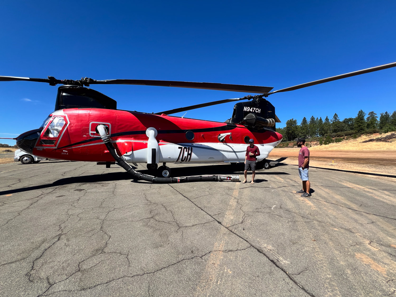
This Chinook helicopter is huge. I can’t remember the details now. I think it can carry 2000 gallons of water. (I may have pulled that number out of the air and I can’t ask Matt right now. I just asked Mr. Google and see that Chinooks of various configurations may carry 2500 to 3000 gallons and fill at a rate of 4000 gallons/minute.)

The Chinook fills with a retractable snorkel. There are windows down low in the front to give a better view of the ground.

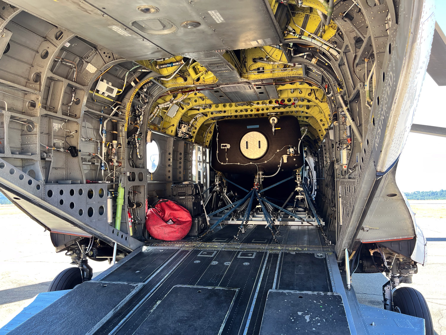
This is the cargo area.

If the Chinook is called into action this whole crew goes with it. There is a fuel truck, and a maintenance/mechanic truck and trailer. I think Matt said that two mechanics are with the team at all times.

After seeing the helicopters we drove to Matt’s house outside Pollock Pines and shared a firefighter lunch he had brought with him. There are a lot of calories there–needed when on the fire line.

Then we drove up the mountain to take Ralston for a swim.

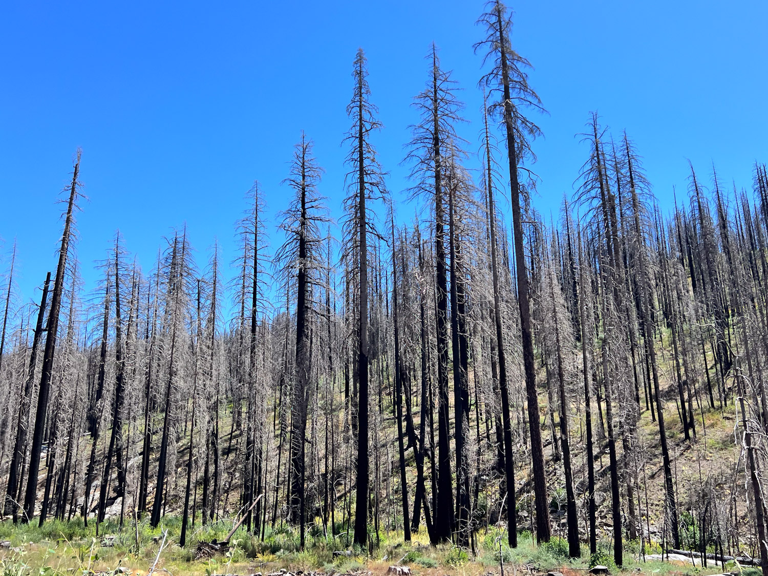
The destruction of the Caldor Fire in 2021 is obvious.

On lands that are privately owned much of the burned timber was harvested while it could still be used for lumber. Trees have been replanted, but I won’t see the return of this forest in my lifetime.

Road Trip 2024 – Day 8 – Heading Home

This post describes what happened on Day 7 and why our week long road trip took eight days. If you’re just tuning in and would like to start from the beginning go back to this August 11 post.

First thing in the morning we walked from the hotel to Service Masters where our truck was. I spotted this bench in the waiting area. They confirmed that the alternator was the problem and that they have the best luck using a Ford manufactured Motorcraft part in a Ford truck (only about $300 more than the other one we bought). We walked back to the hotel to kill time until we needed to check out. Then we walked back to Service Masters where we waited until the truck was ready.

Screenshot

We got on the road just before 1 p.m.

I took this photo because of the Clown and how it relates to Day 2. I don’t understand the fascination with clowns, but after writing the first post in this story I have a new understanding of the Clown Hotel in Tonapah, so I guess I can accept it. In looking through my photos I noticed the gas price–$3.49 is a lot less from my last fill-up here at $4.79.

Mountains east of Salt Lake.

Heading west. The Kennecott Copper mine is to the south and the Tailings Pond is to the north.

Kennecott Copper Smelter

Salt, “harvested” (or is it mined?) from the Great Salt Lake.

Metaphor: Tree of Utah, also called Tree of Life is described by http://www.utah.com: “Swedish artist Karl Momen created the 87-foot high tree between 1982-1986. He financed the project himself to bring bold color and beauty to the stark, flat, salty landscape. The sculpture is made of 225 tons of cement, almost 2,000 ceramic tiles and five tons of welding rod, and tons of minerals and rocks native to Utah.”

East of Wells, NV

Not too many more photos. I spent most of the rest of this trip reading a weaving book that’s I’d had with me the whole way. Most of the time I wanted to see the scenery, but I’ve been on this highway enough that I didn’t need to watch the whole time.

We crossed the border to Home about 8 p.m. I think we made it home a little after 10.

That’s the trip in green. Too bad the odometer on this truck doesn’t show up most of the time so there is no mileage record.

I just came back to edit this post. I meant to thank my Farm Sitters for handling things while we were gone. Four different Farm Club members took shifts so we could be gone for this length of time. I am grateful to them!

Road Trip 2024 – Day 7 – Colorado NM, then Utah

We are winding down this adventure and the stories about it. Yesterday’s part was Day 6. We made it to Colorado National Monument at dusk and found a campsite.

I woke up early and wanted to explore the area.

I walked to the nearby Visitor Center (closed at that hour), picked up a brochure and map, and started walking the Canyon Rim Trail.

This is a view of Monument Canyon as the sun comes up.

A view of the valley we’d driven through to get here. The towns of Fruita and Grand Junction are along the Colorado River. The road switchbacks its way along the canyon walls. It’s amazing to read the stories of how this road was built in the early 1900’s with one man, John Otto, the instigator and tireless promoter of this monument. After walking this trail I went back to the truck to see if Dan was up.

He and I walked the same trail later that morning.

Views of the canyon. Click to see them larger (I think).

Here is a panoramic view of he same landscape. There was more spectacular scenery as we drove the road that winds through the monument. We came in from the Fruita side on the east and left going to Grand Junction. This monument was designated in 1911 and I had never heard of it. I only found it by seeing it on our maps. It is well worth the visit. Maybe someday we’ll have the chance to go back and walk some of the trails.

While we were driving through the monument Dan noticed that the battery warning light was blinking. We thought we had dealt with that with the alternator replacement less than 24 hours ago.

We drove into Grand Junction and found another O’Reilly’s. They tested the alternator and battery and declared them both OK. When you have the hood of the car up in front of an auto part store, other people (guys working on their own cars) come to see what’s going on and offer advice. There were a few who had opinions about the problem. One of them recommended that we go to Sparky’s to have it checked out. Sparky wasn’t there and the UPS driver, who was also looking for Sparky, sent us to ASAP, who sent us to Big O. That Big O send us to a different Big O that would have the equipment to check electronic stuff. They tested the alternator and some other electrical things and declared everything OK. That put us about three hours behind our plan for the day.

We got on the road, thinking it might be possible to make it home by early morning if we slept a few hours in a rest stop.

We were still driving through beautiful country. This is east of Green River.

North of Helper Utah on Hwy 6.

At Green River we drove north towards Price, planning to take I-80 as the fastest way home. About half way to Salt Lake City there is a small town called Helper. If this wasn’t already Day 7 of a seven day trip I would have stopped at a museum there. I was intrigued by the name as well as the scenery through this canyon. I found out that Helper was a hub for coal mining and the railroad. From the Helper website: “Helper is named for the extra engines historically required to help trains up the steep mountain grade to Soldier Summit.” I may not have made it to the museum, but now I have spend some time on the website and found this video, Helper, UT, Where Coal Meets Canvas, that tells about the modern revival of a town that was on a steep decline with the end of the coal mining era. It is an 11 minute video that is an uplifting story.

North of Helper Utah on Hwy 6.

That plan of driving almost straight through was short lived.

When we were between Provo and Salt Lake City the warning light came on again and the battery gauge showed that we were losing charge quickly. Dan pulled off the freeway at a shopping center in Draper and we called AAA. This was about 8:30 p.m. The tow truck driver recommended a mechanic who he said would fit us in first thing in the morning and he dropped us off at a motel that was near enough for us to walk to the mechanic.

To be continued again…

Road Trip 2024 – Day 6 – Trouble on the Road

I wrote the previous post about this trip a week ago. Now I have to look at the map to figure out where we were for some of this. There was beautiful scenery throughout the trip, but there were a few days where the main memory is of things that happened on the road. This is one of those days.

Reminiscent of Day 3 with the highway backup west of Green River, traffic came to a stop on Hwy 24, just west of Hartsel, Colorado. The plan was to get to Colorado National Monument on the western border of the state so we could explore and camp there. We were planning to turn north at the upcoming junction (where there are cars to the right in the photo) or the next one, taking us through Leadville.

It turns out that neither choice was going to be possible, at least not for hours. The accident that had stopped traffic involve a fatality. As we waited, we could see that CPR was underway…until it wasn’t. At that point we were told that cars would have to turn back. Our only option for continuing west was to head back southeast to Cañon City and catch Hwy. 50 going west.

We saw beautiful country, I found it interesting that we were following the Arkansas River, the river I had walked along every morning while in Wichita only the month before.

I noticed the unnatural look to this part of the forest and thought maybe it had to do with logging. Now I wonder if those are all ski runs because this is home to Monarch Mountain ski resort.

Monarch Pass, Hwy 50

The pass is at 11,312′. Our truck that is used to living at almost sea level was not happy about these high mountain highways.

More gorgeous country along the way. At some point Dan saw that the truck’s battery gauge indicated a problem. He had replaced the battery just two weeks before this. We made it to Gunnison and knew that we needed to figure out what was wrong before going farther west. This was a Sunday afternoon–not a lot of options in a small town if we needed a mechanic. I found the address of a towing business and we saw the owner washing his truck, He agreed with Dan’s opinion that it might be a bad alternator. He directed us to Ace Hardware and O’Reilly’s which were both open. We started with Ace, looking for a tester of some kind. When we told them the problem and that we were heading west they alerted us to bridge work being done between Gunnison and Grand Junction. Road crews were replacing welds on some of the older bridges and there were road closures in effect. Hwy. 50 uses two bridges to cross Blue Mesa Reservoir. The Ace employee looked on his computer to find the schedule and showed us that there was a two hour window from 4:30 to 6:30 to get across those bridges if we were to continue the trip that evening.

It was about 4:15 when we got to O’Reilly’s where an employee tested the alternator and found it to be the problem. They had one that would work for this truck and told us we could park in the back to install it. Notice the black car behind Dan. That was someone replacing a radiator so he could continue on to Texas.

Dan bought one tool and borrowed another and was able to replace the alternator.

We made it to the first bridge just after 6:00…

…and to the second about 6:15.

The cliffs in this photo are part of Colorado National Monument, and we made it there as it was getting dark.

To be continued…

Road Trip 2024 – Day 5 – Colorado Springs

I’ve been at the computer a lot, but haven’t had time to finish this story. I usually start with a photo of our campsite, but we stayed in a motel in Trinidad after seeing the Cowgirl Artists show. This day we were headed to Colorado Springs to visit Dan’s brother.

We stopped in Pueblo along the way just to get out of the truck and wander around a bit.

We found a shady place to park and walked into the old downtown. This bike was one of many that we saw painted in bright colors. I didn’t notice if they all have the same message. I suspect that they are all different. This one: “Life is like riding a bicycle. To keep your balance you must keep moving.”

This is the old train station. Notice the blue bicycle leaning on the lamppost.

There were lots of brick buildings. I took this photo for a reason.

Did you notice who is climbing up the side? I got a kick out of seeing Batman and Robin from the old TV series on the wall.

Another interesting building. We drove onto Colorado Springs.

We stopped near a park where we thought we might walk along the river, but then we saw that the Olympic & Paralympic Museum was right across the street. There is access from these stairs that go up to a walkway and down the other side.

The walkway comes out near the main entrance of the museum and since we were in the middle of the 2024 Olympics it was fun to watch a portion of it on the large screen that was set up outside the museum. They were broadcasting swimming at this time.

This was a difficult place to take photos. It’s also difficult to describe. You enter on the bottom level. After you pay you get a badge on a lanyard. You can use that to sign in to computerized presentations, many of which are interactive, throughout the museum.

After the initial check in you take the elevator to the top floor. The museum is set up so that you spiral down through many different exhibits. This case held Olympic torches from many of the Games. I hadn’t realized that all the torches are different.

There were a few opportunities to try out sports via video. I chose skiing over archery.

As you follow the path through the layers of the building there are dozens of different displays about everything from the professional staff that is required to support all the athletes (did you know there is a Team Mom?) to highlights of specific games, stories of individual athletes, and information about gear and clothing.

I’ll end this post with a sweater that I recognized. This was the sweater worn by the athletes at the opening ceremony of the Winter 2014 Games. It was designed by Ralph Lauren and knit from wool grown in Oregon. The whole process supported U.S. businesses. I remember writing a blog post about this yarn when I used it in an Artery show and there I found this link to a video about the ranch and the creation of this sweater. It was worth another watch.

We drove to my brother and sister-in-law’s house and spent the night there.

Road Trip 2024 – Day 4 – Cowgirl Artists

The first half of Day 4 is in this blog post. It’s the destination at the end of Day 4 that was the incentive for planning the first Road Trip we’ve taken since 2019!

Trinidad, Colorado

That destination was Trinidad, Colorado.

The reason for going to Trinidad was the opening of a show Called Women’s Work put on by the Cowgirl Artists of America. From the website: “Celebrating the true contributions of Women in the American West…Much Western art is an ode to the work and contributions of men, while often limiting women to a single sphere, or pretty face. “Women’s Work,” a groundbreaking exhibition that teams artists up with women on working ranches, turns that notion on its head. By showcasing Western women as multi-faceted contributors to the Western way of life. Furthermore, Women’s Work aims to provide a platform for Indigenous women to authentically share their own stories, rooted in their intimate connections to culture and heritage. Traditional and fine artists are included, with all work on the theme of “Women’s Work.

I was not one of the juried artists but was contacted last summer and asked if I’d like to be a farm partner. That sounded like fun so Amy Hanley visited in the summer and we talked about sheep farming and the other things I do. It turns out that Amy is not only a ceramic artist but a weaver. She bought some yarn and told me about the piece she planned for this show.

The show was held at the A.R. Mitchell Museum of Western Art.

This is a view of the two levels of the gallery. The Woman’s Work show took up the whole second level. What a gorgeous place for this show!

There were 56 artists represented. I took photos of a small number of pieces. You can see all of the work and descriptions in the catalog here on the Cowgirl Artists of America website. The descriptions below each piece in this blog post are taken from the catalog.

This is the piece by Amy. It’s hard to tell from this photo but look at the next photo to see that the design is made by weaving in her ceramic button shaped beads.

The views from different angles give unique patterns of color. Very impressive!

Laura Petrovich-Cheney makes fabulous “quilts” from salvaged wood. She contacted the ranch/farm partners last year to find out if we wanted to send wood scraps for her work. I asked if she’d like fabric scraps instead, partly thinking of shipping to the east coast, but also that my fabric scraps are better than any wood scraps around here. So all the fabric pieces in the work above are from me.

This piece is glass mosaic by Lauretta Newby-Coker.

I spent some time talking with these ladies, the artist on the left and the partner on the right. Barbara Meikle donates a percentage of each sale to support horse, donkey and wildlife rescues.

Beverly Moran, of Lakota heritage, creates stunning beadwork, wearable by horses and people. Visit her website to see more.

Morgan Buckert builds custom boots.

Emily Boksenbaum is another boot maker but she made these chaps for the show. Mejo Okon painted the piece to the left of the chaps and also the artwork on the poster (below) that was in the window of the gallery.

I didn’t do a very good job with this photo because of the glare on the glass. Great painting though. I am considering entering this show again, partly as a farm partner, but also with my own weaving. I need to make start weaving some samples of the idea that Dan gave me for this entry!

Road Trip 2024 – Day 4 – Sand Dunes

I just looked at when I wrote about Day 3 of our trip. At this pace it will take me 3 more weeks to finish the story. I need to speed this up. There are more stories to tell after this.

As told in the last post, we found a road on USFS land and pulled off to the side to park. It was dark by then so we could only see what the headlights of the truck showed. Looking back now at the GPS data on my photos I see we were not too far east of Mancos on the San Juan National Forest. In the morning we got on the road and headed east on Hwy. 160.

We drove through beautiful country heading northeast from Pagosa Springs towards Wolf Creek Pass. The scenery was markedly greener than during the previous days.

The old green truck that is used to living at 30′ elevation wasn’t happy about the climb to 10,000+ elevation.

Standing with one foot on each side of the Continental Divide.

From the pass it was about two hours to Great Sand Dunes National Park.

After spending some time in the Visitor Center and learning about how these dunes were created we walked to the dunes.

This is another place that I could come back to.

You could spend a whole day exploring this landscape. There are 30 square miles of dunes! There are no trails through them but you can walk anywhere.

This is a panoramic shot of the closest dune field and shows the mountains at over 13,000′ where you can find alpine lakes if you’re willing to hike. Most of the park is not accessible by vehicle.

There were plenty of wildflowers on the surrounding land. Prairie Sunflower.

Rocky Mountain Bee Plant

Road Trip 2024 – Day 3

If you’re just tuning in you can see Days 1 and 2 here.

Red sunrise over brush.

I woke up in time to see the sunrise at Great Basin National Park.

Here is another view of our campsite.

Sign with map of Wheeler Peak and trails.

The only paved road in the park winds up to the trailhead to Wheeler Peak (13,063′ elevation). We didn’t plan on hiking all the way to the peak but hiked to the lakes at the base. The hiking is all above 10,000′.

Stella Lake is the first of two lakes along this trail.

Deer in green grass and logs behind.

This doe posed nicely for the camera.

Wooden sign about Teresa Lake with the lake and trees in the background.

This sign indicates that we were about a mile from the trailhead where we started on this loop trail. However, there were signs that said the area was closed due to ongoing work. In fact, the road had been blocked before we got to the end and we’d parked lower than we first planned. Law-abiding citizens that we are, we didn’t take this trail back but took another fork and ended up back-tracking over most of the way we had already walked.

That just meant that we got to spend more time in this gorgeous area and put in about 6 miles that morning.

I’m always the one taking photos. Dan took this one so that I could prove I was there. Funny story, and maybe an example of things to come on this trip–there were two large trucks in this parking lot waiting to get past the gate that is just to the left of those porta-potties. They were full of rock or gravel or whatever they were using for the road surface. However the gate was locked and no one had a key. The drivers were trying to find the right tools to take the gate apart. I figured that one of the trucks could have just rammed the gate (being just a pipe) and driven through, but I wasn’t going to suggest that. We were able to move our truck around to get between the two big ones, but then the traffic was stopped on the way down until the pilot car that was with these trucks could make it down the mountain. So these was the first delay of the trip.

We planned to go to the visitor center and maybe see the Lehman Caves.

We spent a little time at the Visitor Center and I made a point of finding these Tempestry panels, knit by my friend, Lisa. They depict the daily high temperature for a given year and location, in this case 1916 and 2016 here at the park. You can find out more about the Tempestry Project here. This is the same idea I use in my Year to Remember blankets

This was Thursday afternoon and we needed to be in Trinidad Colorado by Friday afternoon. We didn’t have time to take a cave tour, so we’ll have to go back.

We took Highway 50 across Utah. This highway is known as “The Loneliest Road in America”, at least in Nevada. It gets a bad rap because it can be desolate, but this area in Utah known as the San Rafael Swell is stunning. (Click on one of the photos to enlarge and scan through them.)

We were somewhere west of Green River when the traffic stopped. We spent about two hours in stop and go traffic, mostly stopped, with no where to pull off. A friend (the afore-mentioned Lisa) and I were texting at the time and she found a a clue to what was going on–there had been a police chase that ended in a fatality.

Later I searched for myself and found a local news report that confirmed a chase that followed an attempt at a traffic stop. The driver passed into the median and eventually wrecked the car killing himself and another person. By the time we got to this area where we’d be able to get to an offramp our truck indicators showed that it was overheating.

We finally got to the exit and were able to let the truck cool down. Fortunately it hadn’t caused damage.

We headed south towards Moab as the sun was setting.

Not long after we turned south two sheriff trucks passed with lights and sirens. One of them weaved back and forth, stopping traffic. We were the first vehicle behind the trucks. The deputy told us that there was a pursuit in progress and, if the vehicle being pursued hit their trucks, then we should “get out of here”. That was a little nerve wracking, especially after the last episode and seeing these cops with guns drawn. Eventually the car drove past in the northbound lane with at least a dozen cop cars following. The car was being driven on rims–there must have been a spike strip that the driver ignored. All those vehicles went by and then these two turned around and followed It seems as though for the next hour we continued to see law enforcement vehicles going that direction. I never did find out what that chase was about.

These stories are not the most significant ones of our trip, but the situations pop to the top when we think about the day.

We drove south on Hwy. 491 and into Colorado and then turned east on 160. I followed the big map book and found where the highway was bordered on both sides by USFS land. There were some roads shown on the map where we could get off of the main highway. We didn’t need a campground as long as we had a safe place to pull off. We were in the San Juan National Forest and found a road that turned north. We found a spot where we could pull off that road. I think we were still eating bagels and bagged salad that we brought from home. That was dinner. We rolled out the sleeping bags in the truck and went to bed.

Road Trip 2024 – Day 1 & 2

Finally…another Road Trip. The last real trip Dan and I made was in 2019. Yes, we drove to Estes Park last year, but it’s not the same when you have a trailer full of sheep and can’t stop to play along the way. This trip was planned to coincide with the opening night of an art show in Trinidad, Colorado, but I’ll get to that in a later post.

I drove my granddaughter to the airport Tuesday morning (July 30), and we were finally packed and ready to go by about 5:30 that evening. How do we get away when there are all these sheep to take care of? Thanks go to Farm Club members who were able to spend two to three days each to take care of sheep, the garden, and of course, Ginny.

We have our phones, but I sure like to follow along with real maps. We can find a lot of interesting details along the way, figure out USFS lands where we can camp, and get a broader overview of an area. Then I use my phone to look up odd place names and read background info as we travel.

Some of my photos will be “drive-by” where there are plenty of windshield splotches visible. I haven’t been in the higher Sierras lately. I don’t think I’d seen this devastation from some of the fires over the last couple years. I think this was from the 2021 Caldor Fire that burned in the El Dorado National Forest and beyond. There were miles of devestation.

We drove east on Hwy. 50 and turned south towards Markleeville and then Hwy 395 on the east side of the Sierras. It was dark by the time we were near Mono Lake where we decided to spend the night. We got gas ($6+/gallon) as the last station was closing in the nearest town. Then we found a place to park the truck and camp.

This photo is from the next morning. Our style of camping is to bed down on the platform Dan made in the back of the truck. I sleep on a foam pad and a sheepskin and am almost as comfortable as in a real bed.

It’s hard to imagine that this was once part of the lake. The sign in the next photo says that in 1994 the State Water Resources Control Board set a target level of 6392′ which is 25′ below the lake level in 1941.That decision decreased diversions by Los Angeles from four Mono Lake tributaries.

I don’t know how much progress has been made but there is still a long way to go, The mandated level of the lake will be at the base of these signs

We walked down the board walk to the lake edge.

From The Geology and History of Mono Lake: “Along the southern shoreline of Mono Lake, large tufa towers or pinnacles rise above the water’s surface. These iconic pillars, comprised of precipitated calcium carbonate, formed over thousands of years by the interaction of freshwater springs and the highly alkaline waters of Mono Lake.” This website also says that when the water diversions were stopped in 1994 the lake was at about half the water volume and twice the salinity of what it was before the water diversions began.

Mono Lake
Mono Lake

After exploring a bit of the lake edge we got on the road. We planned to camp at Great Basin National Park, on the eastern edge of Nevada, Wednesday night.

We have always wondered about the Clown Motel which we discovered on a trip through Tonapah when we made a decision to NOT stay there and try another. It is even more clown-themed now than I remember it from before. I just looked it up and found that in 2019 it was purchased by someone who embraced that theme and has modernized the motel. I read more and found that there is a history to the clown theme. You can see that here if it intrigues you.

We made it to Great Basin National Park by about 5 p.m.

I needed to get out of the truck and get some exercise. After we chose a campsite I followed a trail along the nearby stream about a mile and a half. We didn’t see any warnings about bears, but I started thinking about them and wondered if hiking by myself near dusk was a good idea, especially with the recent fatality in CA by a mountain lion. The only bear encounters we have had were at Grand Tetons and Yellowstone, but maybe it’s the older I get the more I know that sometimes things go wrong. I decided to turn around. I still enjoyed the beautiful scenery.

This was our camping spot.

Granddaughter Visit – Birthday Beach Day

Kirby’s last full day here was her tenth birthday and the day after the fair. She had celebrated with the other set of grandparents in Dixon when they picked her up from the fair on Saturday afternoon. When we discussed what she’d like to do for her birthday, she asked to go to the beach.

We had got home from the fair with the sheep after dark the night before. We could all sleep in a bit on Monday (as if I ever really sleep in). Kirby came out for chores and gave her sheep, Rose a treat.

One of my Farm Club friends volunteers at Pt. Reyes National Seashore, so I had talked to her about where to go. She thought Drakes beach would be a good choice and that’s where we went.

The cool temperature was a welcome contrast after the Central Valley heat.

But Kirby didn’t keep her sweatshirt on for long.

One of the goals we had while Kirby was here was to help her create some entries for her 4-H show in January. We were so busy that we didn’t get very far on those, but I remembered that photography was one of the categories she could enter. I gave her my iPhone and Kirby took dozens of photos. As I saw her running at the hundreds of birds on the beach I gave her an idea.

I suggested that she practice holding the phone in position while running and then be able to hold it still and click as soon as she stopped.

She took several photos that way as well as some still life photos that she carefully arranged.

Kirby also asked me to take posed photos of her.

We spent a couple of hours at Drakes Beach but then drove to another. This is a view of Point Reyes Beach South from above. Here there were signs about a dangerous undertow and the beach has a much more severe slope where the waves are crashing.

We spent some time looking at the sea creatures that were washed up with every wave. These burrowed quickly as the wave receded and all that gave them away was a small hole in the wet sand.

I think I like this photo of Kirby best because it features her wonderful smile.

Is there something wrong with this picture? I didn’t take off my jacket or wool hat all day. I also forgot about sunburn on an overcast day. didn’t realize that Kirby would be sunburned by the time we went home.

Here is the sunburned birthday girl after dinner. She had a real birthday cake on Saturday and she was going to have another back home. With the fair and then the beach trip I didn’t try to make her a cake, but I remembered the blueberry muffins that Kirby and I had made using her Harry Potter cookbook. We had put some in the freezer to save for later and I thawed them and surprised her by turning them into a birthday dessert.

On Tuesday Kirby and I got up at 4:30 so she could make her early flight to Texas. She made a visit to the barn to say goodby to Jade before we left.

Dan and I were leaving that afternoon for our own adventure…next post.