Hawaii – Day 5, Part 1

I have been back for less than 10 days and this Hawaii vacation seems like a world away…I guess because it is. Back home it’s cold and drippy and I have battled a bad cold and eventually won.

I just spent a good part of the day sorting through hundreds of photos so that I could print some for a photo book for Kirby, share a lot with my family on Shutterfly, and finish up my blog posts. I am discouraged to find that I have had to edit so many to remove lots of spots. Some were from an outwardly dirty lens (my fault for not paying attention) but others are spots that I can’t clean. My camera and lenses need to go to the camera doctor and be cleaned inside. The dirt really shows up with blue sky and ocean landscapes.

Dan had left for home (life of a teacher) on Tuesday night. Chris and Meryl left for home on Wednesday. The rest of us visitors wanted to see what we could of the island before leaving the next morning and still get back to spend the evening with my father-in-law and his wife. We started by driving up the mountain towards the Mauna Kea Observatories, hosting telescopes operated by 11 different countries.

Do you see that white spot on the skyline in the photo? The telescopes are at 13,796 feet above sea level. The mountain itself rises 32,000 feet above the ocean floor. There are a lot more facts and a cool photo of the mountain top at this link. We didn’t make it all the way to the top. The visitor center is the recommended stopping point for all 2-wheel drive vehicles, especially rented ones as well as for all children. We had a full day ahead of us without including a trek to the mountain top (beside the fact that we had a toddler with us) so we satisfied ourselves with a look around the visitor center. The other photo shows an array of telescopes that I assume are put into service for special viewing.

Our next stop, a couple of hours away, was Hawaii Volcanoes National Park.

IMG_7785We spent a little time in the visitor center and museum but mostly drove through the park, getting out to look at points of interest…DSC_3470…and take photos…DSC_3491 Kaleena & Kirby…a lot of which, unlike most of my exploring/hiking trips were of family. DSC_3514 K'sI’m not sure that even amazing, steaming volcanoes can compete with beautiful family pictures…that is, pictures of beautiful family.DSC_3524However there were plenty of other arms to hold Kirby on this adventure so I did try to get some photos of our surroundings, especially of the area of rain-forest where we walked. DSC_3541While much of the Park is more desert like this part of the trail is through lush rainforest.DSC_3554

DSC_3532 Matt & Kaleena

DSC_3536 fern

DSC_3531

DSC_3547This had already been a long day for Kirby but she did well in her backpack.IMG_7806This is on the wall to the entrance to the lava tube.DSC_3549Lava tubes are formed as slow moving  lava cools to form walls, but the inner hot lava continues to flow.IMG_7810

IMG_7814Leaving the lava tube.DSC_3517 Meridian tourSeen in the parking lot. Should I decide to move to Hawaii, do I have a job waiting for me?IMG_7817Catching a nap before Part 2 of the Blog.

Road Trip – Day 6 – Another Day at Yellowstone

In the last post did I say how cold it was when we went to bed the first night in Yellowstone? The cold plus the bison in the campground make me wish that I didn’t have that middle-of-the-night call of nature. However, maybe that’s a good thing because it was starting to rain and I shut the tailgate and the camper window. When everything is shut up it is warmer inside, but it is also stuffy and the windows get wet with condensation. There are trade-offs and stuffiness is probably better than feet in a wet sleeping bag especially when the temperature dips into the 20’s. The green truck is too old to show the temp but that’s what my iPhone said when I asked. So instead of rain we had snow during the night. Not a lot, but nevertheless, snow. Once again we didn’t linger over our breakfast of instant oatmeal but got in the truck and turned the heater on.

I chose way too many photos for this day’s blog and I should cut some out, but I probably won’t. I like blogs that are mostly photos…

Our plan for this day was to drive the northern loop starting with Mammoth Hot Springs and ending with the Grand Canyon of the Yellowstone.DSC_4745Not far from the campground we saw our first grizzly bears – from the safety of our truck. (Even though I have been told by blog readers that the bear we saw in Grand Teton was a grizzly bear and not a black bear we thought it was a black bear at the time and I prefer to think that we were hiking with black bears, not grizzlies.) The one on the left was eating a carcass of something and was wearing a collar. They were being watched by a park biologist. I wonder if the park personnel always keep track of bears that are collared and monitor them when they show up near a road? One thing that we learned quickly is that being a Park Ranger in Yellowstone means Wildlife Traffic Patrol. Do you know an easy way to spot wildlife?DSC_4801Just look for parked cars and people walking along the road.DSC_4750It didn’t take long to find more bison…DSC_4755 …and more bears. This one wasn’t alone.grizzly bear grizzly bearI know, the sagebrush is more in focus than the bears, but that may be my last grizzly bear photo.

It was still early and when we got to Mammoth Hot Springs Terraces the weather was not looking good. It was cold and windy and during our walk along the boardwalk trails it started snowing. But the changing conditions only made the views more dramatic.DSC_4781Mammoth Hot SpringsDSC_4779 

Mammoth Hot SpringsDSC_4790  We didn’t hike any long trails on this day but there were many shorter hikes.Scanning for bears, Wraith Falls Trail There were people stopped on the road watching a black bear when we got out of the truck to take a half mile trail to see Wraith Falls. Dan was trying to decide if the bear was still entertaining people on the road or had retreated in our direction. Note bear spray with orange cap in the backpack pocket.

There are several one-way roads that you can use to get off the main road. Blacktail Plateau DriveBlacktail Plateau Drive is one of them and the scenery is majestic.Wild flax To my surprise Dan asked if I wanted to stop and take flower photos. I am usually teased about this habit. This one is wild flax.Phlox Phlox.

blue flower

I wish I knew what this flower is. From a distance it looks like single blue flowers. It’s only when you get up close that you see that it is lots of little tiny flowers.1936 Yellowstone tour busWe stopped at another waterfall trailhead and Dan took this photo of a 1936 touring van that he had just read about. These were canvas topped vehicles used in many of the national parks. They seated 14 people and in cold weather (at least in the northern parks) they provided Pendleton wool blankets for the passengers. At least some of the vehicles were used into the 1990’s when they were just too old to keep running. The Park Service replaced the old vehicles with modern Dodge vans but the visitors wanted the old touring vans. So they are on the road again but Ford kept just the top part and replaced the chassis (and all the important things like brakes) with new parts. raven

Speaking of vehicles it seemed as though each of the parking lots at the main attractions had it’s own sentry. This one was eating crackers.

It was getting late in the day by the time we got to the Grand Canyon of the Yellowstone. There are several access points and trails on both the north and south sides. We knew that we didn’t have time to hike all the trails, but we went to  all the overlooks and walked a few of the trails. Uncle Tom's Point trail to Lower FallsWe took Uncle Tom’s trail to a viewing spot of the Lower Falls. Writing this blog I’m in a tank top and shorts with the fan on and it’s hard to remember that just 10 days ago I was bundled in two layers of wool, my Carhartt jacket, wool hat, and gloves. Uncle Tom's Point trail to Lower FallsOriginally this trail had over 500 steps and rope ladders. Now it has only 328 steps and no ladders. Lower FallsThe trail no longer takes you all the way to the bottom but you still hear and feel the power of the water cascading over the rocks. I love the green color of the water here.DSC_4922 This is a scene of the canyon and the river taken from another viewing area. Simply majestic.Osprey in nest I don’t think that I would have spotted this osprey nest except that some other people were looking with binoculars.Osprey in nest See what I mean? The top photo is a close-up of this one.Grand Canyon of the YellowstoneDSC_4961Another beautiful evening. Again we got back to camp at dusk, ate a couple of cans of beans and went to bed.

Next post: On the road to Oregon


Road Trip – Day 5 – Yellowstone

The mosquito situation in camp was no better than the night before so we didn’t linger in camp on our fourth morning. We took just enough time to get our food out of the bear box and for Dan to make his coffee and we got on the road. There are plenty more trails to explore in the Tetons and I hope to make it back there some day.DSC_4525 But this was our next stop and we had two days to see as much of it as we could.Bison Not far into the park we saw our first bison. Initially we didn’t stop for much  because we needed to find a campsite in one of the non-reservation campgrounds. After we secured a spot we were free to plan the day. There are two main loop roads in Yellowstone and we spent the first day exploring the southern one. DSC_4530 This is the Norris Geyser Basin, not far from our campground. That steam on the left was rising out of the ground with the sound of a roaring a furnace. The trail traverses this valley and there are steamy, boiling, gurgling features everywhere.

I took Geology my first quarter of college and decided that I would not be a geologist. I am definitely more of a life sciences type, but I can be awed by these spectacles even if I don’t know the physical science behind them. This landscape is all about color, patterns, bubbles, steam, explosions.DSC_4538   Bison footprints Bison footprints.DSC_4576  DSC_4597 DSC_4604 DSC_4616 DSC_4655 Blue Star Spring in Upper Geyser Basin Upper Geyser Basin Then there is the wildlife.Bison on road along Firehole RiverOn the way south towards Upper Geyser Basin (where Old Faithful is) traffic was stopped on the road. Going around a turn we saw the cause. Bison were walking alongside and on the road. Why not? It was certainly the easiest way to get from one meadow area to another, especially where this canyon narrowed. Passengers scurried ahead of their cars (leaving drivers) to get a better look.DSC_4568Eventually it was our turn to pass the three dozen or more bison as they turned from the road and moved into the forest.Osprey  Osprey over the Upper Geyser Basin. We got to the Visitor Center and Old Faithful just minutes before Old Faithful was due to erupt. After watching we faced a furious wind as we walked a couple of miles along the boardwalks and trails that traverse the Basin, seeing more of this amazing landscape. Craig Pass, It was getting later in the day as we completed the loop road to get back to camp. The road crosses the Continental Divide a couple of times in this area. Living on the West Coast we always think of all water ending up in the Pacific, but crossing the Divide twice in a short distance made me think about it.  We had been following two major waterways, but they end up in different places, the Snake River flowing westward and the Yellowstone River flowing east.DSC_4741 As dusk falls even more animals are visible, although not easy to photograph. It was dark by the time we got back to camp for dinner. I walked up the hill to the bathroom and a woman who was waiting while her cell phone charged pointed out to me what looked like … nothing…well maybe more black than the rest of the dark. There were two bison munching on grass right next to an RV. In the dark it was as though there was a Black Hole. I would never have known they were there. The woman told me that the bison had just walked around the bathroom and stopped to graze there. At that point I decided that the weak batteries in my headlamp were not adequate for the task of walking around Yellowstone at night. 

No moths or mosquitoes at this campsite, but it was dark when we got back, we were out of firewood and it was cold. We quickly cooked our spaghetti and some hot chocolate and went to bed.

Stay tuned for Day 6.

Road Trip – Day 4 – More of the Grand Tetons

DSC_4359 It was cool in the mornings at Grand Teton National Park, but the main reason to suit-up was to keep the mosquitoes off. They were awful–not very conducive to hanging around camp in the morning. That was not our plan anyway — too many places to see, too little time. As soon as Dan had his coffee we were ready to go.DSC_4360 Look who came to the campground for breakfast.DSC_4366 Hiking near String LakeOur first hike for the second day in Grand Teton NP was around String Lake. DSC_4394 Yellow-bellied marmot.Avalanche chuteAt several places there was evidence of avalanches that took out all the trees in their paths and… avalanche chute …obliterated the trail in some places. DSC_4410DSC_4422 Crossing the river at Jenny Lake we saw our first moose.DSC_4428 This is another moose we saw in a meadow along the road on the way to our second stop of the day.

Lunch stop, "Solid 10 for style and effort"

We drove to trailheads at Lupine Meadows…DSC_0463…where we had lunch. You can’t tell from the photo but it was very windy here. Dan sprinted to chase down a plastic bag that blew quite a distance across the parking area.  One of the visitors later stopped at our truck and told him that he and his passengers gave him a “perfect 10 for style and execution”.DSC_4443 We were near the south end of the park and decided to backtrack a short way down the valley to see the National Museum of Wildlife Art. That will be a blog post by itself.DSC_4472 Back in the park we went for another hike, this time to Taggert Lake.DSC_4475 There are magnificent views though out the park.IMG_0062 

Signal Mtn trailAs the sun was going down we drove to the top of Signal Mountain. More spectacular views, but also an unbelievable number of mosquitoes.Signal Mtn trail from Signal Mtn.
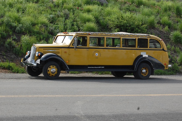
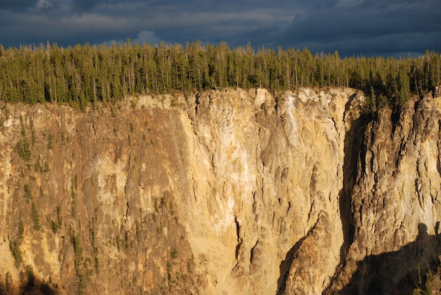
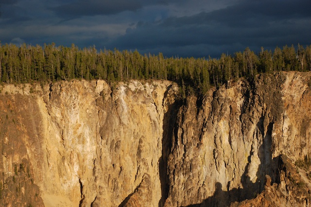
Late evening view from Signal Mountain.

Once again we got back to camp after dark, so we cooked our meal (spaghetti) and went to bed.

Road Trip – Day 3 – Grand Tetons

Morning of the third day.IMG_0055This is the Snake River near where we camped. We were on the road to Primary Destination #1, Grand Teton National Park. Leaving Jackson, WY DSC_4264 Moose is the headquarters and main visitor center for the Park. We found a campsite and chose a place to hike.supplies including bear sprayWe purchased the necessary supplies. That’s Bear Spray on the right. Yikes!bear warning sign These warnings were everywhere you look – at trailheads, in restrooms, on brochures. OK. I believe…But it won’t happen to me? Right? (Read the fine print on this–that’s scary.)DSC_4267 We chose the Hermitage Point trail, about 9.5 miles. Here’s a view across Jackson Lake. The hardest thing about writing this blog is choosing only a few photos.Arrowleaf balsamrootThe stunning Arrowleaf Balsamroot was everywhere.DSC_4316On the trail.DSC_4291I don’t think National Geographic will be calling me anytime soon, but it was fun to try and get wildlife photos. I think I do better with flowers because I can get closer and they don’t move. But maybe this isn’t bad considering that my longest lens is only 135 mm. DSC_4323Ruffed grouse, according to my bird book.Tent caterpillars These tent caterpillars were everywhere. They eat all the leaves in the area of their tents and can be quite devastating when in large quantities.DSC_4318 Swan Lake DSC_4338I didn’t see any swans in Swan Lake, but there were plenty of geese…sandhill crane …and a sandhill crane.DSC_4334  

We were less than a mile from the end of our hike and nearing dusk when we came upon this in the trail.DSC_4346OK. Time for 2 photos and then retreat.DSC_4346 - Version 2 This is an enhanced closeup of the photo above. The signs all say that the bear is supposed to go away. She didn’t. We backed up and Dan fumbled with the bear spray. I had read the instructions while he was driving but I don’t think he paid attention. “Flip off the orange safety catch with your thumb and then position it in spray position. No, point it at the bear, not us…” Did you know that you have only 4 seconds of spray in one of those cans? Not like the wasp spray we have around here. The bear approached a little more and we retreated more. We were less than a mile to the end of the trail and I really didn’t want to go back. Then we saw other people coming up the trail towards us. These were 3 kids (well, college age) who we had seen on the trail before. It turns out that they didn’t have a map with them and had taken a wrong turn to a dead-end trail, backtracked, and were running to make up time back to headquarters. They were thankful that we stopped them or they would have been running straight at the bear. When we saw a cub come out from behind a log and it was evident that this mama bear was not going to retreat we turned around and started walking the other way. It added only about another two miles to the hike for an 11.5 mile day. (Is this over-dramatic to those of you who live in bear country? I’m sure that I have hiked in bear country before, but I’ve never seen them. The difference is that these animals are not as wary of people as they would be other places–which is great if you want a deer or grouse photo, but not so much an animal with big teeth and claws.)DSC_4357 Sunset over Jackson Lake.

Road Trip – Day 2- Craters of the Moon

NOTE: As I was writing this I realized that I am back-tracking over yesterday’s post. Oh well. Just like the book that I read on the trip–jumping around from generation to generation.

On Day 2 we awoke at the rest stop to trucks rumbling out and millions (it seemed) of moths folded up in the truck. We shooed out as many as we could and packed up. As we followed the California Trail east we pulled off at the CA Trail Interpretive Center about 10 miles west of Elko. This looks like a brand new facility and is probably worth a stop on another trip, but it was closed at that hour.

At the town of Wells, NV (population about 1300) we turned north towards Twin Falls, ID and there we saw a marker for a CA Trail historical site. It showed a view of the route of the pioneers–dry, desolate, rough terrain, sagebrush. The town wasn’t much. There were many abandoned old brick buildings but there was one in use and it showed a sign for the Wells Society for the Preservation of Western Heritage. Their CA Trail Museum was open. We were shown around by a young woman who grew up in Wells and told us that most of those abandoned brick buildings were in use until 2008 when the town was devastated by a 6.0 magnitude earthquake. DSC_4192 - Version 3DSC_4192 - Version 2DSC_4193

Now we catch up to the photos of lunch and “Welcome to Idaho” in the previous post. Driving past Twin Falls to Shoshone and beyond we were awed by the green landscape. I am used to California’s huge agricultural landscape but there was something different about this. Maybe because of the miles of wheat with huge pivot irrigation systems. DSC_4202Unfortunately I didn’t take many photos and although this photo shows the huge pivot it doesn’t give the feel of the landscape. Deep, deep green over rolling hills to the distant horizon. We read later that this area is fed from aquifers that are a result of the volcanic landscape north of us. And of course there is the Snake River and the dams up the river, including the 15-mile long Jackson Lake in Grand Teton National Park which was dammed in 1911 for irrigation in Idaho.

But Idaho isn’t all green landscape. We stopped at Craters of the Moon National Monument. DSC_0420There was a short trail to the top of Inferno Cone.DSC_4215Can you tell it was windy? So windy that Dan’s sunglasses blew off and he had to chase them down the slope. We gave up on wearing hats.DSC_4218This is the view from the top of Inferno Cone. The Visitor’s Center is just right of center. Notice the plume of smoke on the horizon at the left. That continued to grow and drift across the whole landscape through the afternoon.DSC_0437 This is on the trail around Broken Top, a cinder cone. Still windy.IMG_9929There are caves to explore. This is the path to three caves.DSC_0446 Getting out of the wind to the quiet of the cave was a relief. This is Indian Tunnel, a cave with areas in which the roof has collapsed.IMG_9936Most of the time it’s too dark in a cave for photos. The beauty of this area is in texture, color, and shape. (Hey, weavers, substitute  structure for shape and we’re describing cloth.)DSC_0451      DSC_4233DSC_4234DSC_4235DSC_4254 Craters was not our primary destination so after seeing what we wanted to see (and being tired of the wind) we got back on the road. The evening was spent driving through more beautiful ag land in Idaho, following the Snake River. DSC_0454At dusk we found an almost empty campground along the Snake River. After a meal of beans and popcorn we went to bed. No moths. No wind. Perfect.

Next installment: Grand Tetons.