Road Trip to CO – Mesa Verde

It has been a few weeks since we finished our road trip and there have been plenty of distractions since I’ve been back that have kept me from sharing the story. Now that the Olympics are on  TV I am trying to multi-task. But it’s hard to pull my eyes away from the TV at times.*  However I’m close to finishing–we are still in Colorado but once we headed for home we didn’t stop for much.

After we left Black Canyon of the Gunnison  National Park we looked at our trusty Benchmark map book for Colorado and saw that we could probably get to Mesa Verde National Park in time to spend the night there. So after driving through the marvelous San Juan Mountains it was a relatively short drive from Durango to Mesa Verde. We got there about 6 p.m. and found that there were plenty of open campsites.

DSC_1323

We looked at the Park maps and saw a couple of 2-mile trails that we would have time for before dark. First we hiked up to Point Lookout at 8427′ elevation. This view is to the northwest with the San Juan Mountains in the background and the town of Mancos in the center.

DSC_1295

Squirreltail…

DSC_1313

…and Indian rice grass along the trail.

DSC_1311

DSC_1321

DSC_1326

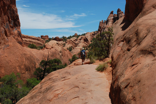
After getting hiking this trail we drove to the the Knife Edge Trail which follows a section of the precarious road built in 1914 which was part of the original main access into the park.

IMG_2869

IMG_0407

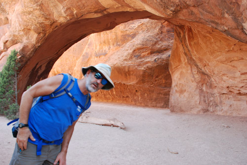
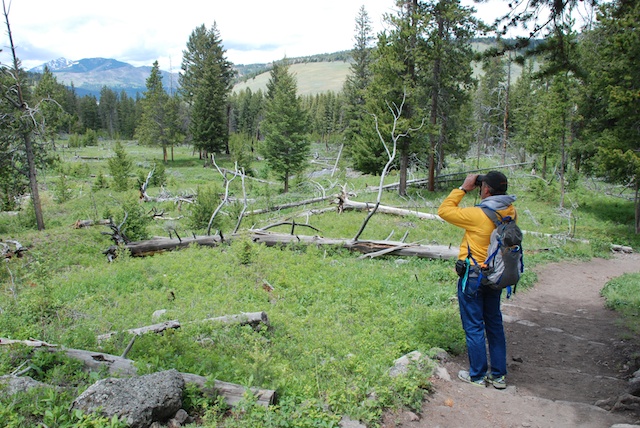
Dan took this photo of me with the booklet that described the plants and other features along this trail.

IMG_2866

IMG_2874IMG_2875

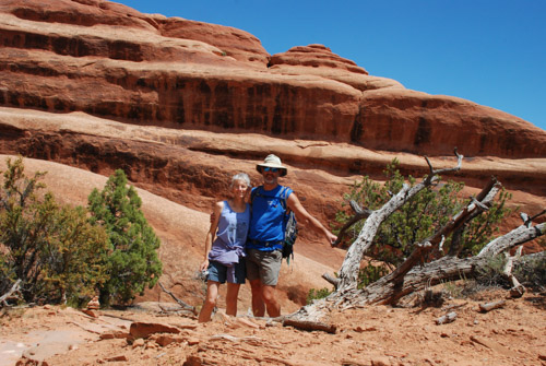
This is a popular place for park visitors to watch the sunset. We walked back to the car at dusk and it was dark when we found a campsite. With the dark it got cold and we didn’t have a working stove. We ate tuna sandwiches and went to bed. DSC_1358

This is what camp looked like in the morning.

DSC_1354-2.jpg

There were deer around the camp in the night and at dawn when I got up.

DSC_1366

Seen on my early morning walk.

IMG_2876

We had learned when we paid for our campsite that the way to see the features for which the park is best known (the cliff dwellings)  is to sign up for one of the tours. We showed up the next morning for the Balcony House tour.

IMG_2877

We were directed to follow the trail to the end where we would find a ladder and to wait there.

IMG_2881

This tour is listed as the “most adventurous cliff dwelling tour” and we were warned that we would “climb a 32′ ladder, crawl through an 18″ wide by 12′ long tunnel, and climb up a 60′ open cliff face with stone steps and two 10′ ladders”. Not quite an Indiana Jones adventure but it did seem challenging for some of the tour participants.

IMG_2882

Can you imagine what this was like when people really lived here?

IMG_2902

I can see the challenge of being a mother of a toddler.

The Ancestral Pueblo people lived in the Mesa Verde area for about 700 years from about AD 550 to the 1200’s, first living in pit houses, then above-ground pole and adobe structures. The people built the cliff dwellings from the 1190’s to 1270’s and lived there for less than 100 years. It is unknown why, in the span of a generation or two, the people left the area.

IMG_2910

Ranger Spenser was glad to answer questions and discuss his passion for the earlier residents of these dwellings.

IMG_2908

Each village or homesite has a kiva built below ground or in the case of the cliff dwellings, into the rock floor.

DSC_1386

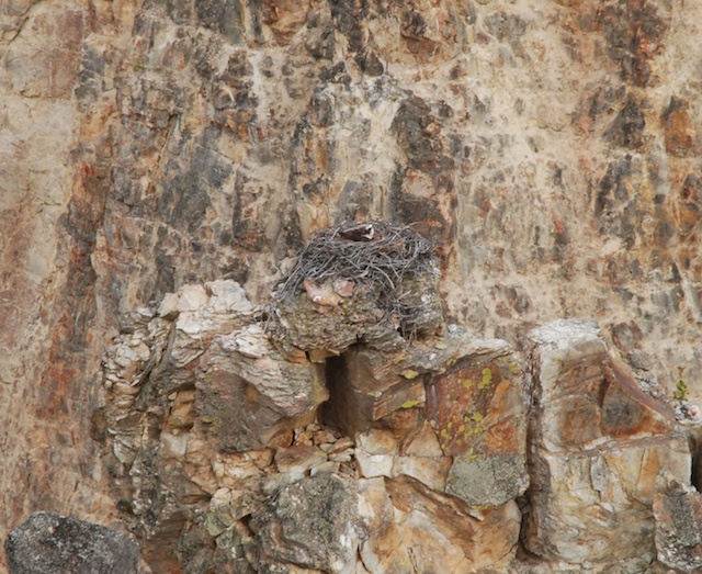
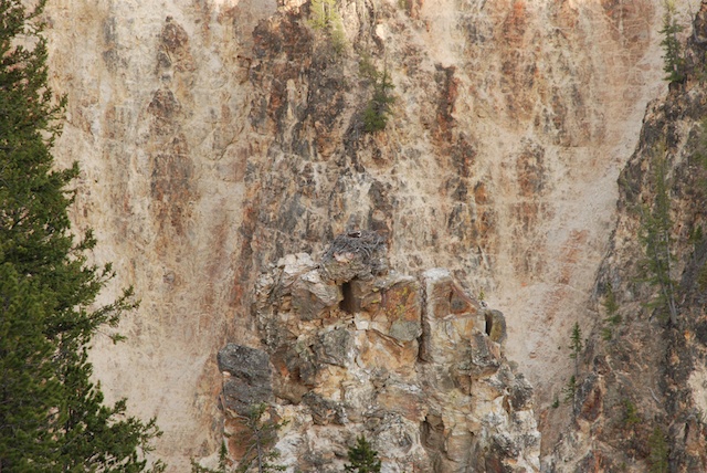
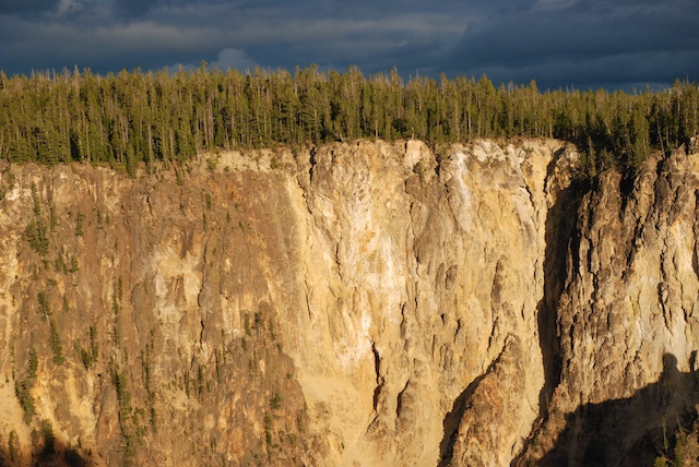
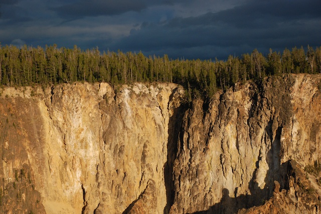
This is the view across the canyon from Balcony House.

DSC_1384

This is the same view with a longer lens. It was remarkable that when you really started to look (or got out the binoculars) that you could see dwellings in many of the cliff walls.

DSC_1376

Here is another that we saw later in the day…

DSC_1378

…and here’s the close up. This is known as Square Tower House, a 4-story building.

IMG_2920

Remember the part about the 18″ x 12′ passage. Here it is…

IMG_2923

…followed by the ladders…

IMG_2924

…and steps up the cliff wall.

We drove through more of Mesa Verde, looking at some of the other sites, but knew that we needed to get on the road if we were to get home some time the next day.

Next post: Four Corners and Monument Valley.

*I still didn’t get this finished and now its the next day.

Road Trip to Colorado – Arches N.P.

The mosquitoes that had been relentless the night before (this post) were slightly less so in the morning.

IMG_2631

However the surroundings were beautiful as the sun reached the west side of the canyon.

IMG_2628

But we didn’t linger around camp. We packed up and drove just north of Moab to the entrance of Arches National Park.

DSC_0801

The cliffs on the left side of the photo are part of Arches and that’s the Colorado River flowing our of the canyon in the center of the photo.

IMG_2632

I had been here once or twice before but that was almost forty years ago. (Oh yeah, I was going to find my old slides and see if I have photos from back then.)

I don’t remember the names of all the arches. Besides sometimes I don’t want to know what names other people have used for formations. I like to enjoy them without always having to see or think of something that is not a rock. I’ll make up my own name if something comes to me.

IMG_2636

We had one day to see the park and, knowing that it was going to be a hot day, we decided to start with one of the longer trails. Out and back on the more traveled trail would have been about 5 miles. We ended up taking the “primitive” route to come back and that was 7 miles.

IMG_2648

I thought about giving up taking photos because it seem so hard to capture the grandeur, the color, the textures.

IMG_2655

But of course I continued to shoot photos and I am sharing some of my favorites.

DSC_0816DSC_0818

IMG_2663

Distances are so deceptive in this country. We had seen these rock walls in the distance and I had thought, “it’s a good thing we’re not going there”. The “primitive route” took us around those and beyond.

DSC_0852

Cairns are important in finding the trails over slickrock and through washes. Seeing those little rock towers kept us on track in places where the trail wasn’t obvious.

DSC_0854

DSC_0857

DSC_0838

More from Arches National Park in the next post.

A White Christmas

We spent a lovely Christmas Day with my son and other family members. We got there in the morning before everyone else so that we could spend some time in the forest that is their backyard. I am not a snow person, but I can brave it occasionally, especially when the sun is out, and I’ll admit that it was a nice touch to have a beautiful snowy view from inside Matt & Kaleena’s warm house with a fabulous woodstove to back up against. The morning began, however, with us  sliding backwards down Matt’s driveway in our Explorer. (I am planning to sell this before the next smog deadline, so no new tires for us.) That little glitch solved (by rocking the Explorer out of the snowbank and then parking at the bottom of the hill), we geared up with showshoes and foot warmers in our my boots and walked down to Jenkinson Lake. DSC_4315

DSC_4271

DSC_4301What time I have spent in the snow has been well after the storms have come through. There is something very different and beautiful about being there immediately after the snowfall…DSC_4310…while the branches are still heavy with snow.DSC_4264

DSC_4263

DSC_4283I loved seeing the snow clear to the tops of the trees. As the sun started warming the trees, snow cascaded from the highest branches.DSC_4295I spent the night at M & K’s (Dan came home for chores and dog duty) and the next day Dan came back and brought Chris and Meryl with him. Then we celebrated our private family Christmas.IMG_8003The younger generation helping the older one with digital issues.DSC_4321Chris plays a mini-flute sporting his new Storm Trooper oven mitt.IMG_8019Here are my sheep/barn related Christmas gifts. My wheelbarrows constantly need their tires pumped up so Dan got the fittings to go on an extra air compressor in the barn. There are tubes and tires for my handtruck. Dog treats from Hawaii. Sheep and dog magnets. All the attachments for my new GoPro (birthday present). Footrot Flats is a comic strip series that I think only a sheep farmer would enjoy. Hand and foot warmers packets that I’ll share with Farm Club in the barn. IMG_8013We took another hike that afternoon. This was a great two-day Christmas celebration with family. And it’s not quite over. The kids are taking us to see StarWars in a couple of days. The only thing missing was my granddaughter and her family but at least we spent a week with them not long ago.


Walking in the Woods

I went to a party at my kids’ house in Pollock Pines but I went a few hours early to do a little hiking. They were busy with getting ready so I went off by myself. I don’t do that very often–at least not somewhere other than around here. I guess I wasn’t completely alone because I had Ginny with me. I couldn’t take all three dogs because the property below where my kids live is part of the Sly Park Recreation Area and dogs are supposed to be on leash–I can’t deal with all three on the leash. Besides I didn’t want three dogs party-crashing.

This is a leisurely walk, all downhill at the beginning and then around the lake. As usual I had my camera and this time it didn’t matter how long I sat in a field of yellow flowers to get the right photo. There are hiking and horse trails all through the area and I walked down one that…DSC_5950…meets up with a short nature trail that follows a creek on it’s way to the lake.

Cedar bark dwelling

There is a cedar bark dwelling replica just off the trail.Sly Park, Jenkinson Lake
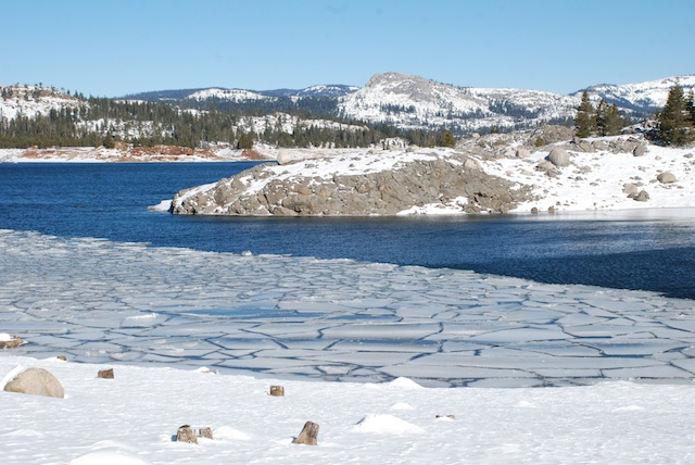
This is Jenkinson Lake. There camping areas all around it and lots of people on this Memorial Day weekend. I had Ginny on the leash and she had a lot of lessons in good behavior when meeting kids, bikes, etc. Matt had told me that it was about 10 miles from their house, around the lake, and back. When I was standing here I though that maybe I’d do that instead of just an out-and-back walk. I would continue to the left in this photo, go around the dam in the center of the photo and back to their place.DSC_5868After walking some more I came to this part of the lake and decided that maybe an around-the-lake walk wasn’t going to work for today. This is a finger of the lake that juts back up the valley and I would have to walk all the way around this part and the main part of the lake in the other photo. So I went a little further up the west side here and then turned around but took a higher trail back that avoided some of the crowds that were nearer the lake.DSC_5873This is Ginny sitting on the dock. She didn’t seem to care that the ground under her was rocking.DSC_5884That low growing shrub is mountain misery and here are some close-ups.Mountain misery, Chamaebatia foliolosaMountain misery is unique to the western slope of the Sierras and there is a lot of it. It has a pungent oily sap and can play a role in preventing erosion to hillsides in the years following major fires. On the other hand those same deep far-reaching roots use up a lot of moisture and may prevent other plants from becoming established. Mountain misery, Chamaebatia foliolosaI don’t live in the mountains so don’t deal with it as a “weed” and I like the fragrance–it reminds me of the forest after a rain.DSC_5916I came across a small area of striking yellow on a south facing slope. I didn’t identify these flowers but in their midst I found some…monkey flower, Mimulus sp…monkey flowers. At least I’m pretty sure they are Mimulus but I don’t know which species.What I noticed first about them were the seed pods.Monkey flower, Mimulus sp seedpodWhat I noticed first about them were the seed pods.

Monkey flower, Mimulus sp seedpod

DSC_5880 The deep green of the trees was in striking contrast to those yellow flowers but the new growth of the trees is a contrast of greens in itself. DSC_5874Back to the more shady woods, taking one of the trails up to the house.

Wild rose

Wild rose.

Buttercup, Ranunculus

DSC_5858I don’t remember this one but do you see what is on the leaf?DSC_5857

Sly Park, Jenkinson LakeDon’t tell Rusty and Maggie where we were. I feel guilty leaving them home.  This was fun for Ginny and me and Ginny got about 6 miles of on-leash work on manners.

Ice

The older I get the less I want to slip and fall. My body sabotages me enough without doing something that is more likely to break a bone. So on our hike yesterday I was very careful to avoid the icy parts on the trail. But not everyone else seemed to care so much.Sam on iceSam on ice.Ginny walking on ice Ginny on ice.Kirin on iceKirin on ice.Chris on ice Chris on ice.DSC_1387Meryl and Chris on ice.

Chris sliding DSC_1349 Chris on ice–this time on purpose.

Matt sliding Matt’s version of the louge…

DSC_1355 Matt on louge …followed by the skeleton…

Matt - skeleton DSC_1366 Matt - breaking form  Here he breaks form before breaking his head.

Bassi Falls

Yesterday it was way too cold and windy at Loon Lake …Loon Lake …for us to enjoy snowshoeing for very long so we drove back down…DSC_1220…to the trail to Bassi Falls at about 5400′ elevation.DSC_1221There wasn’t enough snow to snowshoe but there was no wind and the other signs of winter were still there.DSC_1247 DSC_1268 DSC_1274 DSC_1283 DSC_1291 DSC_1294 DSC_1302 At the base of the falls Meryl and Chris showed off their gymnastic skills.DSC_1317Bassi FallsHere is a group shot where we’re not quite as bundled up as in the previous post. DSC_1199How many people does it take to arrange a dog-only group shot? You can see the result of this in Rusty’s blog after he gets his turn at the computer.Maggie and Ginny Once again, Maggie provide entertainment for Ginny because just hiking isn’t enough for her.GinnyAfter the trauma of the first stop we made, Ginny had a great time on this hike. We all thought that she would be worn out for the day, but it seems that the long car ride was enough to revive her and she wasn’t at all tired last night.

Loon Lake

It’s not easy to find a time when we can all get together for a whole day. We had planned on a snowshoeing trip and the prediction of a little cold weather wasn’t going to deter us. The problem was that even though we had significant precipitation in December with  Caliornia’s continuing drought the snow level was fairly high. To find enough snow for snowshoeing we drove to Loon Lake (6358′ elevation). There was enough snow here and it was sunny but the temperature was in the low 20’s and the wind was howling. (I know that plenty of people live in this kind of weather, but not me. I’ll go for 100 degree days anytime over bone-chilling cold.)

We decided to go for it with the snowshoes at least for a short time. Everyone out of the car…DSC_1089 …including Ginny, in the snow for the first time.DSC_1093 Matt, Kaleena, Chris, and Meryl started down to the lake with the big dogs. I was behind because I had to remember how to walk with snowshoes without getting my feet tangled up going down the steep slope from the road.DSC_1096 It didn’t take us long to figure out that with the strong wind it was just too cold for Ginny so Dan took her back to the car. DSC_1103 The rest of us continued down to the lake. Matt was having a hard time keeping track of which was his wife since both Kaleena and Meryl were wearing Kaleena’s snow gear.  Edge of Loon Lake There were white caps on the lake and lots of ice at the edge.Ice at Loon Lake

Loon Lake That’s me on the left, then Kaleena, Matt, Chris, and Meryl.

Chris & Meryl at Loon Lake   Meryl and Chris with Sam and Rusty.DSC_1154It’s the wind that is making Rusty’s ears stand up.

We didn’t spend too much time here. Instead we drove back down to Bassi Falls and went for a hike there–something that all of us could enjoy. Photos of that in the next blog post.

Road Trip – Day 6 – Another Day at Yellowstone

In the last post did I say how cold it was when we went to bed the first night in Yellowstone? The cold plus the bison in the campground make me wish that I didn’t have that middle-of-the-night call of nature. However, maybe that’s a good thing because it was starting to rain and I shut the tailgate and the camper window. When everything is shut up it is warmer inside, but it is also stuffy and the windows get wet with condensation. There are trade-offs and stuffiness is probably better than feet in a wet sleeping bag especially when the temperature dips into the 20’s. The green truck is too old to show the temp but that’s what my iPhone said when I asked. So instead of rain we had snow during the night. Not a lot, but nevertheless, snow. Once again we didn’t linger over our breakfast of instant oatmeal but got in the truck and turned the heater on.

I chose way too many photos for this day’s blog and I should cut some out, but I probably won’t. I like blogs that are mostly photos…

Our plan for this day was to drive the northern loop starting with Mammoth Hot Springs and ending with the Grand Canyon of the Yellowstone.DSC_4745Not far from the campground we saw our first grizzly bears – from the safety of our truck. (Even though I have been told by blog readers that the bear we saw in Grand Teton was a grizzly bear and not a black bear we thought it was a black bear at the time and I prefer to think that we were hiking with black bears, not grizzlies.) The one on the left was eating a carcass of something and was wearing a collar. They were being watched by a park biologist. I wonder if the park personnel always keep track of bears that are collared and monitor them when they show up near a road? One thing that we learned quickly is that being a Park Ranger in Yellowstone means Wildlife Traffic Patrol. Do you know an easy way to spot wildlife?DSC_4801Just look for parked cars and people walking along the road.DSC_4750It didn’t take long to find more bison…DSC_4755 …and more bears. This one wasn’t alone.grizzly bear grizzly bearI know, the sagebrush is more in focus than the bears, but that may be my last grizzly bear photo.

It was still early and when we got to Mammoth Hot Springs Terraces the weather was not looking good. It was cold and windy and during our walk along the boardwalk trails it started snowing. But the changing conditions only made the views more dramatic.DSC_4781Mammoth Hot SpringsDSC_4779 

Mammoth Hot SpringsDSC_4790  We didn’t hike any long trails on this day but there were many shorter hikes.Scanning for bears, Wraith Falls Trail There were people stopped on the road watching a black bear when we got out of the truck to take a half mile trail to see Wraith Falls. Dan was trying to decide if the bear was still entertaining people on the road or had retreated in our direction. Note bear spray with orange cap in the backpack pocket.

There are several one-way roads that you can use to get off the main road. Blacktail Plateau DriveBlacktail Plateau Drive is one of them and the scenery is majestic.Wild flax To my surprise Dan asked if I wanted to stop and take flower photos. I am usually teased about this habit. This one is wild flax.Phlox Phlox.

blue flower

I wish I knew what this flower is. From a distance it looks like single blue flowers. It’s only when you get up close that you see that it is lots of little tiny flowers.1936 Yellowstone tour busWe stopped at another waterfall trailhead and Dan took this photo of a 1936 touring van that he had just read about. These were canvas topped vehicles used in many of the national parks. They seated 14 people and in cold weather (at least in the northern parks) they provided Pendleton wool blankets for the passengers. At least some of the vehicles were used into the 1990’s when they were just too old to keep running. The Park Service replaced the old vehicles with modern Dodge vans but the visitors wanted the old touring vans. So they are on the road again but Ford kept just the top part and replaced the chassis (and all the important things like brakes) with new parts. raven

Speaking of vehicles it seemed as though each of the parking lots at the main attractions had it’s own sentry. This one was eating crackers.

It was getting late in the day by the time we got to the Grand Canyon of the Yellowstone. There are several access points and trails on both the north and south sides. We knew that we didn’t have time to hike all the trails, but we went to  all the overlooks and walked a few of the trails. Uncle Tom's Point trail to Lower FallsWe took Uncle Tom’s trail to a viewing spot of the Lower Falls. Writing this blog I’m in a tank top and shorts with the fan on and it’s hard to remember that just 10 days ago I was bundled in two layers of wool, my Carhartt jacket, wool hat, and gloves. Uncle Tom's Point trail to Lower FallsOriginally this trail had over 500 steps and rope ladders. Now it has only 328 steps and no ladders. Lower FallsThe trail no longer takes you all the way to the bottom but you still hear and feel the power of the water cascading over the rocks. I love the green color of the water here.DSC_4922 This is a scene of the canyon and the river taken from another viewing area. Simply majestic.Osprey in nest I don’t think that I would have spotted this osprey nest except that some other people were looking with binoculars.Osprey in nest See what I mean? The top photo is a close-up of this one.Grand Canyon of the YellowstoneDSC_4961Another beautiful evening. Again we got back to camp at dusk, ate a couple of cans of beans and went to bed.

Next post: On the road to Oregon


Road Trip – Day 5 – Yellowstone

The mosquito situation in camp was no better than the night before so we didn’t linger in camp on our fourth morning. We took just enough time to get our food out of the bear box and for Dan to make his coffee and we got on the road. There are plenty more trails to explore in the Tetons and I hope to make it back there some day.DSC_4525 But this was our next stop and we had two days to see as much of it as we could.Bison Not far into the park we saw our first bison. Initially we didn’t stop for much  because we needed to find a campsite in one of the non-reservation campgrounds. After we secured a spot we were free to plan the day. There are two main loop roads in Yellowstone and we spent the first day exploring the southern one. DSC_4530 This is the Norris Geyser Basin, not far from our campground. That steam on the left was rising out of the ground with the sound of a roaring a furnace. The trail traverses this valley and there are steamy, boiling, gurgling features everywhere.

I took Geology my first quarter of college and decided that I would not be a geologist. I am definitely more of a life sciences type, but I can be awed by these spectacles even if I don’t know the physical science behind them. This landscape is all about color, patterns, bubbles, steam, explosions.DSC_4538   Bison footprints Bison footprints.DSC_4576  DSC_4597 DSC_4604 DSC_4616 DSC_4655 Blue Star Spring in Upper Geyser Basin Upper Geyser Basin Then there is the wildlife.Bison on road along Firehole RiverOn the way south towards Upper Geyser Basin (where Old Faithful is) traffic was stopped on the road. Going around a turn we saw the cause. Bison were walking alongside and on the road. Why not? It was certainly the easiest way to get from one meadow area to another, especially where this canyon narrowed. Passengers scurried ahead of their cars (leaving drivers) to get a better look.DSC_4568Eventually it was our turn to pass the three dozen or more bison as they turned from the road and moved into the forest.Osprey  Osprey over the Upper Geyser Basin. We got to the Visitor Center and Old Faithful just minutes before Old Faithful was due to erupt. After watching we faced a furious wind as we walked a couple of miles along the boardwalks and trails that traverse the Basin, seeing more of this amazing landscape. Craig Pass, It was getting later in the day as we completed the loop road to get back to camp. The road crosses the Continental Divide a couple of times in this area. Living on the West Coast we always think of all water ending up in the Pacific, but crossing the Divide twice in a short distance made me think about it.  We had been following two major waterways, but they end up in different places, the Snake River flowing westward and the Yellowstone River flowing east.DSC_4741 As dusk falls even more animals are visible, although not easy to photograph. It was dark by the time we got back to camp for dinner. I walked up the hill to the bathroom and a woman who was waiting while her cell phone charged pointed out to me what looked like … nothing…well maybe more black than the rest of the dark. There were two bison munching on grass right next to an RV. In the dark it was as though there was a Black Hole. I would never have known they were there. The woman told me that the bison had just walked around the bathroom and stopped to graze there. At that point I decided that the weak batteries in my headlamp were not adequate for the task of walking around Yellowstone at night. 

No moths or mosquitoes at this campsite, but it was dark when we got back, we were out of firewood and it was cold. We quickly cooked our spaghetti and some hot chocolate and went to bed.

Stay tuned for Day 6.

Road Trip – Day 4 – More of the Grand Tetons

DSC_4359 It was cool in the mornings at Grand Teton National Park, but the main reason to suit-up was to keep the mosquitoes off. They were awful–not very conducive to hanging around camp in the morning. That was not our plan anyway — too many places to see, too little time. As soon as Dan had his coffee we were ready to go.DSC_4360 Look who came to the campground for breakfast.DSC_4366 Hiking near String LakeOur first hike for the second day in Grand Teton NP was around String Lake. DSC_4394 Yellow-bellied marmot.Avalanche chuteAt several places there was evidence of avalanches that took out all the trees in their paths and… avalanche chute …obliterated the trail in some places. DSC_4410DSC_4422 Crossing the river at Jenny Lake we saw our first moose.DSC_4428 This is another moose we saw in a meadow along the road on the way to our second stop of the day.

Lunch stop, "Solid 10 for style and effort"

We drove to trailheads at Lupine Meadows…DSC_0463…where we had lunch. You can’t tell from the photo but it was very windy here. Dan sprinted to chase down a plastic bag that blew quite a distance across the parking area.  One of the visitors later stopped at our truck and told him that he and his passengers gave him a “perfect 10 for style and execution”.DSC_4443 We were near the south end of the park and decided to backtrack a short way down the valley to see the National Museum of Wildlife Art. That will be a blog post by itself.DSC_4472 Back in the park we went for another hike, this time to Taggert Lake.DSC_4475 There are magnificent views though out the park.IMG_0062 

Signal Mtn trailAs the sun was going down we drove to the top of Signal Mountain. More spectacular views, but also an unbelievable number of mosquitoes.Signal Mtn trail from Signal Mtn.Late evening view from Signal Mountain.

Once again we got back to camp after dark, so we cooked our meal (spaghetti) and went to bed.