Unknown's avatar

About Robin

Owner of Meridian Jacobs, farm and fiber shop. I raise Jacob sheep, teach fiber arts classes, weave handwovens for sale, and manage the store.

November Adventure – Ironman Arizona – part 3

I left off in the last post with Chris starting the marathon, the third part of the Ironman that was two weeks ago.

This photo is about a half hour into the marathon.

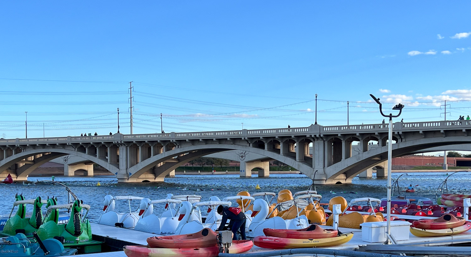
This is a screenshot from my phone very nearly at the end of the whole thing, but I’m including it here to show the course and to show how spectators are able to track their athletes through the day on this app. The blue line in the river (which is truly more of a lake here because of a dam) is the swim course. The green line is the bike course and the red one is the run. It was complicated. The runners first went out and back on the red line that goes to the top of the photo. Then they cross the river and make the loop where it says 129, go down to the bridge at the bottom, run along the river, do that out and back part again and do this whole course three times. On the last one they turn where it says 123 and run to the finish. As spectators we try to position ourselves in strategic places to cheer them on.

This view shows the transition area where all the bikes are and where the athletes had lined up along the river before the start of the swim

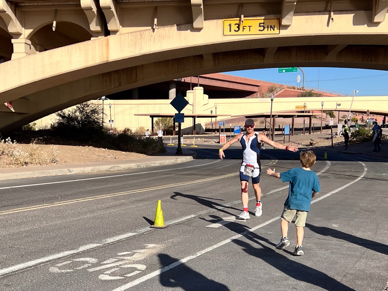
Meryl and Katie and the kids and I walked across a bridge to position ourselves where we’d see Chris twice as he went around the loop on this side of the river. Kasen made sure he got a High 5 in when he could.

This was the best place to be with the Kasen and Kirby because there was a sandy beach for entertainment. It’s a long day for everyone, but especially for the kids.

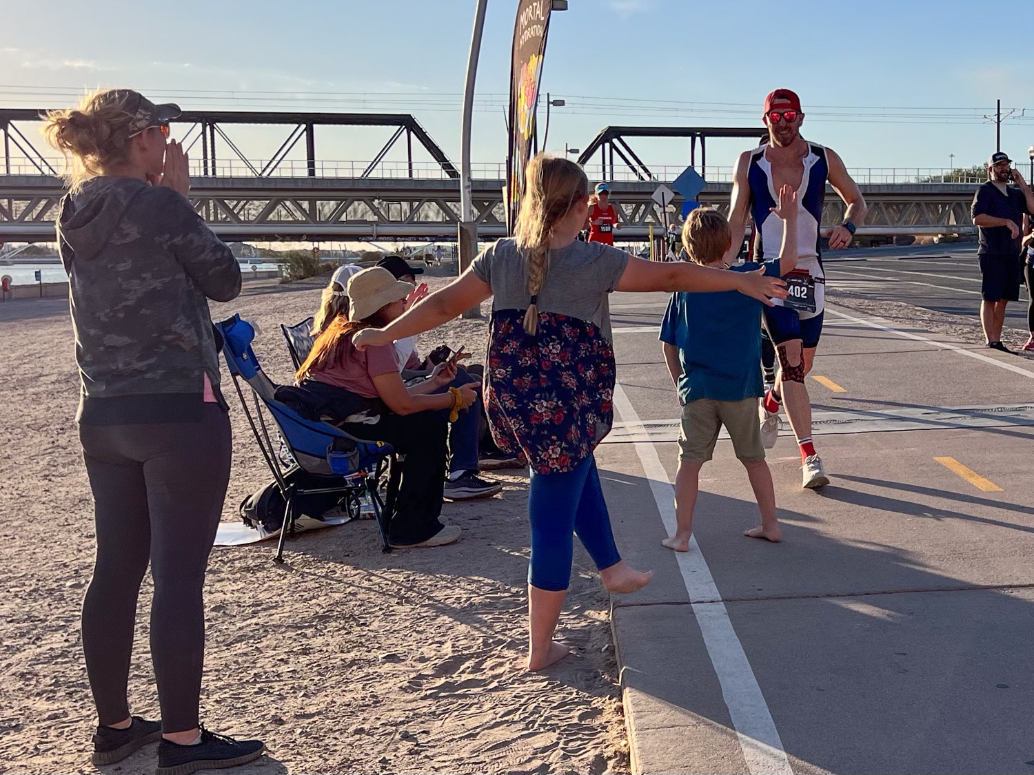
More High 5’s for Uncle Chris from the kids. This is about two hours into the marathon.

At this point I walked back over to the other side of the river where Dan had been greeting Chris as he ran by. Meryl, Katie, and the kids stayed here until closer to the time Chris would finish.

The view back across the river. That arched bridge is the one I had just walked across and the kids were on the beach below there.

This is at about 3-1/2 hours.

The marathon finish.

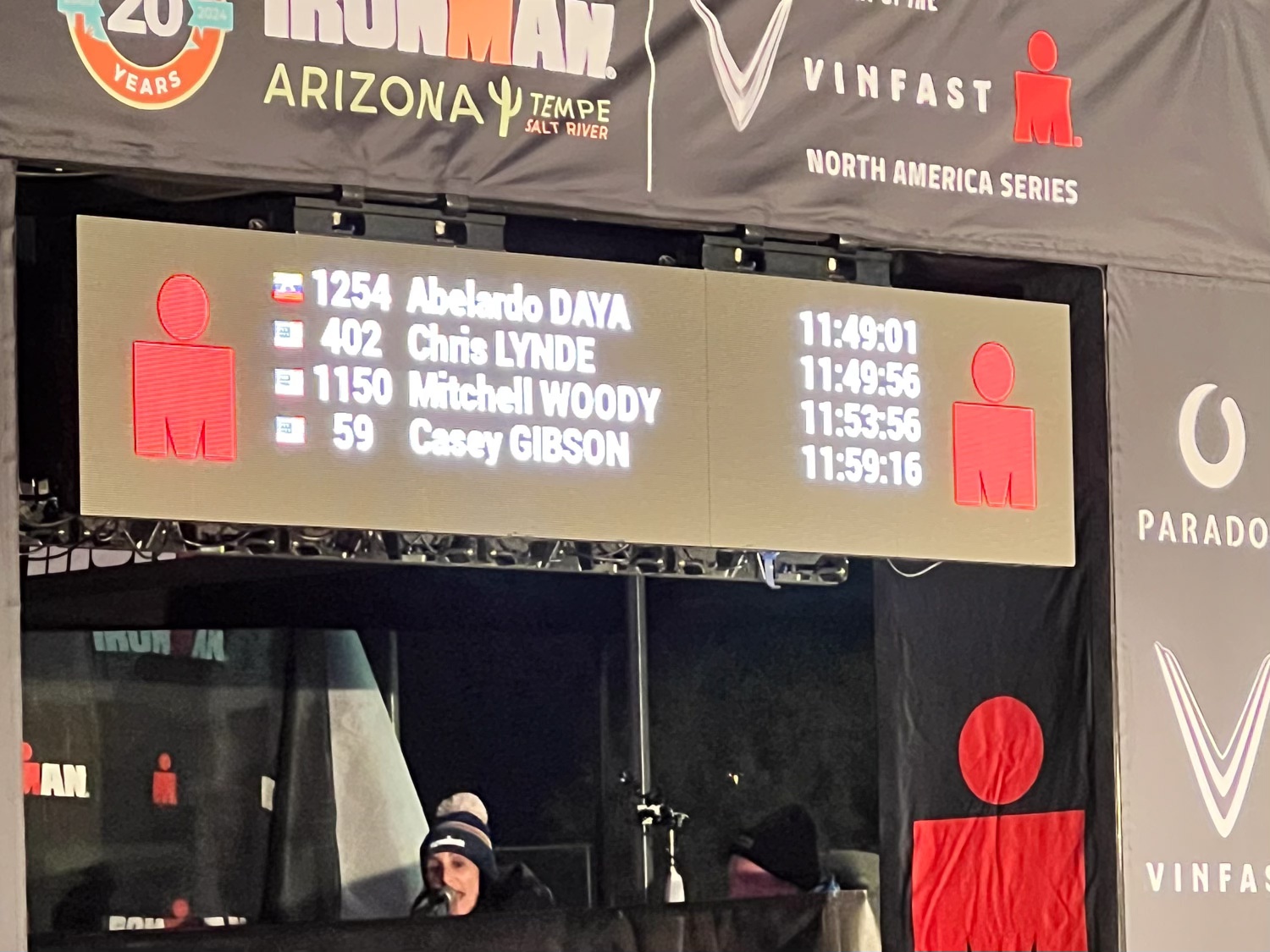
Total time for the whole event: 11:49:56.

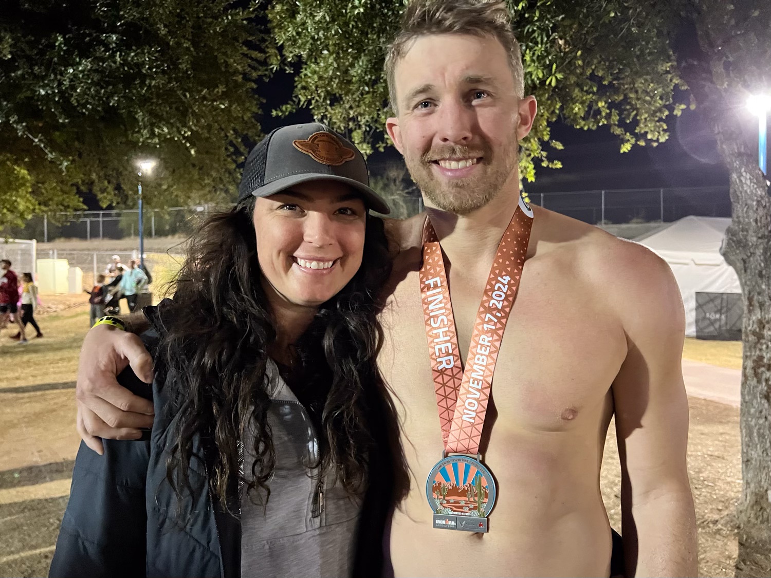
Meryl and Chris wearing a well-deserved finisher’s medal.

The family (except Dan snuck out of the photo). We went back to the hotel where they were all staying. The grandkids played in the pool and the big kids sat in the hot tub while we all rehashed the day. We got together Monday morning for about an hour and then we all had to go our respective directions. Katie had to get a rental car to get back to Safford, Arizona where her car had been towed the previous day after breaking down about 2-1/2 hours from Phoenix (and I had driven to pick up her and the kids, but that’s another story). Meryl and Chris visited a friend in the area for a couple of days and then made a trip to the Grand Canyon. Dan and I had to get home by that evening.

I took this photo just inside California at 11:40. We got home about 8:30 that evening. I sure enjoy hanging out with my kids. I wish we could do it more often.

November Adventure – Ironman Arizona – part 2

In the last post I described the swim portion of the Ironman and saw Chris leaving for the bike portion. That was about 8:25.

Katie, Kirby, and Kasen found us after walking from their hotel.

The bike route went from downtown about 18 miles east. (At least hat’s what I calculate from the total of 112 miles.) The cyclists turned around at that point and came back here and did that loop three times. Notice the hill in the background and the unicorn along the fence to the right.

I don’t know if people wear costumes to provide amusement to the competitors, so they can be spotted by their athlete, or because it’s warmer inside a big balloon.

Just down from that hill in the earlier photo and still in sight of the bike course there was a clearing. Kasen had chosen to pack a football for his entertainment. Katie, Meryl, and Kirby were talked into playing catch.

About two hours into the bike portion Chris showed up here for the end of the first loop. The streets had been blocked so there is a lane for bikes and a lane for car traffic going west.

It was just bikes going east. They made a tight turn-around. When we were watching for Chris we looked for a white helmet, white jersey with the blue patches on the chest, red socks, and the red tape on one knee.

We had six hours to wait from the beginning to end of the bike portion. We wandered some. This was written on the back of one of the signs at the Ironman Village. One of our family slogans is “Move faster.” Chris has give us his own words of advice: “Don’t get off the bike.” “Forward is a pace.”

It was time to climb the hill…because it was there. There was a sign that labels it Hayden Butte Preserve and the Leonard Monti Trail. It is also known as “A” Mountain for the 60-foot gold A painted on part of it that we did not see from our view.

There is quite a view from the top. The street to the left in this photo is where there is one lane of traffic and one lane for the cyclists.

Walking down the mountain back to the course. The white bridge over the river (dammed to be more of a lake here) will be part of the marathon course.

After the third out and back loop the cyclists rode into the transition area where volunteers took the bikes as they dismounted.

A change of shoes to start the marathon. Now we needed to watch for a red cap.

Only 26 miles to go.

There were felt pens and paper at a table in the Ironman village. During the six hours we waited for Chris to finish the bike course the kids made signs.

To be continued again…

November Adventure – Ironman Arizona

The purpose of our trip south (described in yesterday’s blog post) was to support Chris at the Ironman and to be there with Meryl, Katie, and the grandkids.

I don’t have photos to share from the trip from Joshua Tree NP to Tempe on Friday or on Saturday. When we got on the road Friday afternoon we were stopped on I-10 by an accident to the east. It took about two hours to move five miles and even after it cleared traffic was slow. That put us in Phoenix during the commute traffic and we didn’t meet up with Chris and Meryl until late in the evening.

Saturday was the day to check in the bike and set up all the gear. Dan went with Chris and Meryl to do that while I drove 2-1/2 hours east to pick up Katie and the grandkids (Kiirby and Kasen) at a small store at Bylas, Arizona. Katie had left her home in Texas Friday evening but Saturday morning she had car trouble and was stranded. Those two days remind me of our road trip this summer and all the delays due to traffic problems and car trouble. The country was striking, but I refrained from taking photos while driving.

People sitting in a hotel room.

By Saturday evening all of us were together. Kirby and Kasen were excited to have use of the hotel gym and pool after a long trip. The rest of us were ready to call it a day because we’d be getting up early Sunday.

Crowd of people waiting for the start of the Ironman under lights, with office buildings in the background.

We got to the venue about 6 a.m. These events always seem complicated to navigate. There are 1700+ athletes and all the people who are there to watch and support. The transition area has racks with all 1700+ bikes in place and all the other infrastructure needed. There is an Ironman Village with vendors. Streets have been blocked off for the bike course and sometimes the marathon. This was right in the middle of the city.

Maps of the swim, bike, and run course for the Ironman.

The map on the left shows the swim course (2.4 miles). That was in the Salt River, running through downtown Tempe. The start, finish and transitions were all at the far left on the swim and bike course maps and the middle of the run map. The bike portion (112 miles) was three times out and back on that course. The run was three times around that full course to get in 26 miles. As spectators it is our job to figure out where to position ourselves to find our athlete throughout the day.

Chris had been working through a knee issue so he taped it before putting on the wetsuit. No photo, but there is a story to remember about unknowingly flipping his timing chip into the river behind him when he pulled things out of his bag. Someone near by pointed out that something fell in the water and it turned out to be the chip. (All athletes wear the chip because that is how times are recorded and how us spectators can track them on our phones.) Fortunately it was floating near enough to just be able to retrieve it.

Portrait of Chris and Meryl with dark blue sky at dawn.Chris has a gray sweatshirt and Meryl has a black jacket.

Pre-race photos.

Athletes lined up on the path to the swim start, men with green caps, women with pink. That’s Chris in the green cap between the pink and blue ones at the far side. They try to line up in order of anticipated finish time. Chris thought that he’d swim the course in about 1:10 but was behind the 1:30 to 1:40 time sign. It doesn’t really matter because the official time is from when swimmers enter the water to when they finish. That’s why that timing chip is important.

River with swan boats at the dock, a bridge and clouds in the background.

Swimmers got in the water at a platform under the bridge.

They swam east in the river to a turn around point, then back to that red buoy just visible under the bridge on the left, and to the finish.

Meryl and Dan and I wandered around the area hoping to find some sun so we could warm up. Katie and the kids didn’t try to make the start of the race. They walked a couple miles from the hotel to meet us just after Chris’ swim/bike transition.

Blue garbage bins full of numbered bags for athlete gear.

This are the bins full of gear that the athletes left as they got ready for the swim.

Blow up arch that indicates the bike start of the Ironman. Cyclist walking his bike through the arch.

Chris finished the swim in 1:09 and made the bike transition.

To be continued…

November Adventure – Joshua Tree NP on Day 2

I’m interrupting the Pasture and Irrigation Renovation posts (#9 of that series) of the last few weeks because we had an adventure before the project was completed.

Two Road and Recreation Atlas books on my lap. One says Arizona and one says California.

Chris was to compete in the Tempe (AZ) Ironman on Sunday. Dan had gone to Idaho for a visit and to pick up Chris’ bicycle so he wouldn’t have to ship it. We left November 14 (Thursday) with the plan to camp part way and get to Tempe mid-day on Friday.

Sign that says Entering Joshua Tree National Park with blue sky behind.

I took this photo when leaving the park on Friday, because by the time we got to Joshua Tree NP it was dark and I did not take a photo at the west entrance. I did not take any photos that evening. We set up the tent and ate bagels and cheese for dinner. This trip was not intended to be a real camping trip. We just needed a place to stay on the way to Arizona and it seemed that it would be fun to have short National Park experience. When we got there we realized that we hadn’t even brought any water, other than the water bottles we’d already emptied. I have learned that I am not a winter camper. The last (and maybe only other) time I have camped in the winter was at Big Bend National Park in 2017. I know that because I just looked for the blog post and found it. I have the same sentiment now that I did then–you get to a campsite in the dark and it’s not bedtime but you have to get in a sleeping bag to be warm.

Brown tent in campsite with rocks behind. Sunrise glowing in the background.

I think we got in sleeping bags about 6 p.m. I read awhile and eventually fell asleep. I woke up at midnight and the wind was howling and the rain fly was slapping the tent. Dan told me the next day that he wondered if he left the tent in the middle of the night if it would blow away with me in it! I read until I finished a book about 3 a.m. and then slept. I woke up early and thought I’d be better off moving than lying in the sleeping bag for longer. I thought I might find some sun since it was starting to come up.

I found a marked trail not too far from the campground.

I didn’t see any bighorns, but I liked the sign.

Dawn in the desert.

Bird nest surrounded by cactus spines.

This seems like a prickly place for a bird nest, but maybe it’s protected that way.

Remnants of adobe house. It's just parts of walls standing now.

We were staying at the Ryan campground, named for the Ryan family who settled this area in 1896. It’s hard to imagine that 60 people lived here and worked in at the ranch and mine until 1908. This is one of the buildings built of adobe bricks. There are other remnants of the ranch as well.

Desert landscape with mountain in the background.

You can see this structure centered the right of this photo. Those two large rock features are part of the campground and our tent was behind the one on the right.

Old windmill blades on the desert sand with dry grass in the middle. Mountains with sunlight in the distance.

Part of a toppled windmill. At this time the sun had reached the hills across the valley but there was not sun where I was.

Trail through desert with sunrise behind the hills.

I continued my walk until sun appeared over the hill and from behind clouds and I could stand in a sunny spot for awhile.

Tent and picnic table with ice chest and food box.

The tent was still in the shade when I got back. Dan had emerged, but maybe you can tell that he was cold. We didn’t linger there, but packed up and headed for Arizona. We did spend some time in the park, stopping to read signs and take in the sights.

Landscape with rocky points in the foreground and the Coachella Valley below.

This is a view over the Coachella Valley with Santa Rosa Mountains in the background and the San Andreas fault at the eastern edge of the valley.

Cholla cactus in the foreground, hills and blue sky in the background.

We stopped at the “Cholla Garden”, a location along the road filled with cholla cactus.

Close up of cholla cactus, spiny with remnants of yellow flowers.
Dan walking on trail with cholla cactus filling the landscape.

This is a fascinating landscape, and I’m glad it’s preserved by the National Park system.

Sign explaining differenced in Mojave and Colorado deserts.

Another sign tells that Joshua Trees live only in the Mojave Desert and that is in the northern section of the Park. The Mojave and Colorado Deserts overlap in the park and the vegetation in each is different.

Pasture and Irrigation Renovation – Part 9

I wrote the last post about this project 9 days ago. The crew had removed the old standpipe at the northwest corner of the pasture and replaced it with a new concrete box. When we irrigate the box will fill with water and create pressure to force water into the rest of the system.

In the meantime we were concerned with getting seed on the pasture at the best time. Michael had finished putting up borders, even though the irrigation pipeline work would disturb the upper end of the field. We needed all of that work to be finished before seeding. I had ordered the seed mix from a company in Tracy, about an hour and a half from here. I said that we’d pick it up to save on shipping cost and to have it here when Michael was ready for it. This time of year farmers are trying to get the field work finished before it rains a lot and they can’t get on the fields at all.

The day after the irrigation work was done in the corner we drove to Tracy to pick up the seed we had ordered. This photo is the warehouse there. There was some kind of communication problem between the order desk and the warehouse. Our order was wrong. I had paid for 350 pounds of seed but there was only 64 pounds there. The people at the seed company said they’d get the seed to us on Wednesday of the next week. That was the day before we were to leave on a 5 day trip. (That will be in the next blog post.)

The next morning I took these photos (above and below) of Michael smoothing out the edges of the field.

Skip ahead five days. The irrigation crew planned to come out on the 15th. We left that morning for Arizona. I asked my friends who were going to farm sit to take photos of the progress for me.

The crew spread the pipe out in the proper location. Then there was a lot of digging. They used this excavator at the northwest corner.They used a trencher for most of the lines.

The pipe that runs east-west in front of the blackberries has one T to send water south to the other east-west pipeline.

This is the rest of the pipeline at the north end in front of the blackberries.

This photo shows what the valves look like. They will be at ground level.

Here is that first east-west pipeline completed.

Pasture and Irrigation Renovation – Part 8

I wrote the last post about this ten days ago. This project is taking a lot longer than I’d hoped. The last field work was October 31 when Michael put up the borders. It wasn’t until November 6 that the irrigation part of the project started.

This is a photo taken in May when we were starting to irrigate. This is just outside of our fence line. The water is starting to flow down the ditch after SID (Solano Irrigation District) personnel opened a valve. The red wheel controls the position of the gate that lets water into a pipe at the base of that concrete structure.

The water goes through the pipe into the concrete standpipe in the northwest corner of the pasture. There is an opening that faces south and water flows into our ditch. We are replacing the ditch system on our property with a pipeline. We can’t pump because there is no power back here. Therefore the whole system has to work with gravity feed. Engineers from Pacific Southwest Irrigation proposed this system, approved by NRCS.The first step was to replace this standpipe and pipeline

I was surprised at the finesse with which the excavator operator could work around the existing structure. It was important to not damage the concrete structure that has the red wheel control. They had to dig up the existing pipe that went into an opening at the base of that structure. In this view the top of that standpipe to be removed has already been knocked off.

A lot of dirt had to be moved and this pile was a lot bigger by the time they finished.

Some handwork (with a shovel) was necessary to break away the mortar.

They also used a handheld jack hammer to break more away without damaging the concrete box. The excavator loosened the old pipe without damage to the remaining structure.

Eventually they were able to remove the old pipe and the rest of the standpipe.

In the meantime Dan made a frame and poured concrete to extend the walkway behind the barn. The concrete chunks under the new concrete are the leftover parts of that foundation that we hauled out of the pasture after the initial work to remove it.

This is the new pipe.

It was lifted into position and then cut to fit.

The crew dug a pit and made a concrete pad at the bottom.

The next day they installed two concrete box structures with the pipe that connects the SID structure to this one. The view is to the west. That tree is right at the corner of the property.

The view east. This was last Friday. Another crew will be here this Thursday or Friday to work on the rest of the pipeline. We wlll be gone, but that is another story. I need to get my friends to take photos.

A Birthday Hike

My birthday was last weekend and I wanted to go hiking. I thought about Mt. Diablo or Pt. Reyes or Mt. Tamalpais, all places that I’d like to explore, but the thought of Bay Area traffic discouraged me. Then I realized that I could take advantage of some open space that is closer to home.

Lynch Canyon is in Solano County just north of the freeway between Fairfield and Vallejo. In the 1980’s the property was purchased by a company who proposed a landfill. Thankfully that was rejected by Solano County voters and the land is now owned by Solano Land Trust.

The land is rolling hills dotted with oak trees. We had the first real rain of the season the previous evening so this may start to green up soon. On the morning of our hike the vegetation was all dry.

The trail we chose headed generally west. I wanted to get to the top of the hills for the view.

My brother, Dave, was with us.

This area could be stunning when there are spring wildflowers. The only plant flowering now was tarweed.

The thistles were an interesting contrast.

That’s my brother.

Cattle graze these hills right now.

This was a beautiful day for a hike.

Once we got on top of the hills we had views all around. This is looking southeast over American Canyon and the marsh land where the Napa River ends at San Pablo Bay. If I turned around I could see the windmills along Hwy. 12 to the east.

We could see Mt. Diablo to the south.

An easy 6-mile hike was a good way to spend my birthday.

When I got home I walked Across the Road with Ginny. Do you recognize that mountain in the distance? That’s Mt. Diablo at a little different angle than the phioto from Lynch Canyon.

Pasture and Irrigation Renovation – Part 7

As I mentioned in the last post we were concerned with the weather. In some years there could have been significant rain by this time. As it was we’d had only a trace. On October 31 Michael brought a tractor here to put up borders in the field. Brett’s job had been to level the field while creating a slight slope west to east and north to south so that the water would flow. The borders are important to direct the water that will be released from the valves during irrigation.

Green and yellow tractor with orange border maker attached.

This tractor is set up with the border maker. The photo shows the wings that were folded in for transport down the road. That coiled up cable will help to set the distance for the wings to spread out. By the way, those back tires are taller than I am!

Green tractor with orange border maker attached.

A view from the back. The part with the oval cut out will form the top of the borders.

I climbed up and took a photo of the inside of the enclosed cab.

The wings are spread out here to create borders with 30′ spacing. Michael figured out where to start and sets uses GPS (I think) to keep the lines straight.

Computer screen inside cab of tractor.

Michael invited me to ride along. I rode for a few passes until his wife came with lunch and his young son who was going to ride along with him to finish the job. I took this photo of the computerized controls. This reminds me of looking in an airplane cockpit. There are lots of knobs and dials and screens. If you want to do the job correctly you need to know how to set all the parameters. At least the tractor stays on the ground.

Tractor pulling border maker in a dirt field.

This is the last pass down the field.

Prepared dirt showing borders for irrigation. Clouds in the sky.

The next job for Michael will be to come back with a different tractor to smooth out the ends of the field where the borders stop. Michael is doing us a favor by working this 7-acre job. The normal minimum is 40 acres. It makes more sense to use equipment of this size for a larger property.

Red barn in background with blue sky. Field has been disced and has borders for irrigation in place.

Here is how the field looks now ready for seeding.

Pasture and irrigation Renovation – Part 6

The last post ended with land leveling on October 18. Pipe and other supplies had been delivered October 16 but we had to wait for Brett’s work to be finished before starting anything else. The next two parts of this project were to install the irrigation system (Hunter from the irrigation company) and to create borders and seed the pasture (Michael with the field equipment). Initially we thought the pipeline work would be next and we would finish with the rest of the field work. Michael talked to Hunter about the best order of operation here. We were getting worried about weather. It was important to get this work done before there was too much rain that would stall the work. Also both of them have other much bigger jobs that they are trying to finish while the weather holds. I left it to them to work out the best way to accomplish this. Hunter and Michael went to school about the same time, along with my son, Chris. (In fact, Hunter and Chris were on the same rugby team for a season, and Michael’s mom and I carpooled at times to get the kids to school.)

Michael brought a tractor over on October 24. He and Dan and I had walked the field and determined that part of the field could use another discing. That is where the concrete had been. When leveling, that area seemed to have been scraped but left a surface that wasn’t as good for creating the borders and seeding.

Michael had one of his employees disc that portion of the field to help loosen it up.

The next day Dan and I picked up more chunks of concrete that had surfaced. Over the last couple of weeks we had picked up a lot of this that was scattered throughout the field.

Before Hunter could do the first part of the irrigation work Dan had to remove the fence in the northwest corner of the property.

This is the view from the field to the northwest.

The view from outside the field looking to the east. This is part of the SID (Solano Irrigation District) system. There is a metal gate at the bottom of that concrete structure that lets the water into our ditch which is now all filled in and leveled. It will be replace with a pipeline. Dan removed the fence and old posts and other debris from this corner.

To be continued.

Pasture and Irrigation Renovation – Part 5

The last post showed the field being ripped. That was the last week of September. Then we had Lambtown–not that it has anything to do with this, but it’s how I put the dates in perspective and remember where I was..

On October 3 when Brett started discing with the L-disk I taught a class at Lambtown. After that Brett had other work to do in Oregon. I think he thought it would also be helpful for the grass to dry out even more. So he didn’t get back to this until October 18.

In the meantime, the irrigation supplies arrived.

It was unloaded on the square of pasture that is not going to be part of the project.

A few days before Brett was going to level the field he brought the land plane.

It’s difficult to tell the scale when you see the equipment working in the field. In this photo I’m standing near the back tire of the tractor. Brett tells me that those tires cost $8000/pair.

He also brought this tower holding a gadget that helps to laser level the field.

The tractor has he other laser and some how they talk to each other and the scraper and bucket of the level is raised or lowered depending on the desired slope of the field

This stage took about a day and a half.

Brett finished this on October 18.